IMAGES TAKEN NEAR TO
Towcester Road, SWINDON, SN3 4AS
Introduction
This page details the photographs taken nearby to Towcester Road, SN3 4AS by members of the Geograph project.
The Geograph project started in 2005 with the aim of publishing, organising and preserving representative images for every square kilometre of Great Britain, Ireland and the Isle of Man.

There are currently over 7.5m images from over14,400 individuals and you can help contribute to the project by visiting https://www.geograph.org.uk
Image Map (Loading...)


Getting Data...Please wait
Leaflet Map data © OpenStreetMap
Images are licensed for reuse under creativecommons.org/licenses/by-sa/2.0
Notes
- Clicking on the map will re-center to the selected point.
- The higher the marker number, the further away the image location is from the centre of the postcode.
Image Listing (15 Images Found)
Images are licensed for reuse under creativecommons.org/licenses/by-sa/2.0
Image
Details
Distance
1
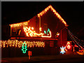
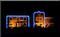
Yuletide in Harlestone Road, Stratton, Swindon (1)
The illuminations on this house were mentioned on our local radio today. This is the first of three photos of the house.
Image: © Brian Robert Marshall
Taken: 12 Dec 2009
0.15 miles
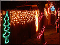
2
Yuletide in Harlestone Road, Stratton, Swindon (3)
The illuminations on this house were mentioned on our local radio today. This is the third of three photos of the house.
Image: © Brian Robert Marshall
Taken: 12 Dec 2009
0.15 miles
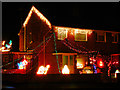
3
Yuletide in Harlestone Road, Stratton, Swindon (2)
The illuminations on this house were mentioned on our local radio today. This is the second of three photos of the house.
Image: © Brian Robert Marshall
Taken: 12 Dec 2009
0.15 miles
4
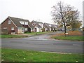
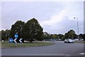
Swindon: Falconscroft, Covingham
The committee entrusted with the task of naming the roads in this large 1960s housing estate obviously sought the solution to the problem in their "Observer's Book of British Birds"! Finchdale, Heronscroft, Wrenwood, all the slightly less common ones are there, even Pipitdene. However sparrows, blackbirds and starlings all got the cold shoulder apparently. This one's Falconscroft off Covingham Drive.
Image: © Nigel Cox
Taken: 12 Oct 2007
0.16 miles
5
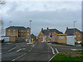
Oakley Park, Stratton, Swindon
A new development that doesn't yet appear on the OS maps, it lies just north of Covingham Drive, Swindon.
Image: © Brian Robert Marshall
Taken: 7 Jan 2007
0.17 miles
6
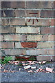
Benchmark on #1 Larksfield wall
Ordnance Survey cut mark benchmark described on the Bench Mark Database at http://www.bench-marks.org.uk/bm56149
Image: © Roger Templeman
Taken: 9 Apr 2015
0.18 miles
7
Junction of Covingham Drive and Larksfield
There is an OS benchmark Image on the wall right of the road name sign
Image: © Roger Templeman
Taken: 9 Apr 2015
0.18 miles
8
New houses, Oakley Park, Swindon
I believe these are the show homes for this new development that does not yet appear on the OS maps, but does on Google Earth. Lit up for Yuletide with perhaps a little more restraint than some others.
Image: © Brian Robert Marshall
Taken: 8 Dec 2007
0.18 miles
10
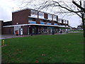
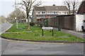
Row of shops, Covingham Square, Swindon
Row of shops including supermarket, newspaper shop and Post Office, pharmacy, and betting shop. There are flats above the shops and a pub just out of the picture to the right.
Image: © Vieve Forward
Taken: 28 Dec 2012
0.22 miles