IMAGES TAKEN NEAR TO
Woodside Road, SWINDON, SN3 4AQ
Introduction
This page details the photographs taken nearby to Woodside Road, SN3 4AQ by members of the Geograph project.
The Geograph project started in 2005 with the aim of publishing, organising and preserving representative images for every square kilometre of Great Britain, Ireland and the Isle of Man.

There are currently over 7.5m images from over14,400 individuals and you can help contribute to the project by visiting https://www.geograph.org.uk
Image Map (Loading...)


Getting Data...Please wait
Leaflet Map data © OpenStreetMap
Images are licensed for reuse under creativecommons.org/licenses/by-sa/2.0
Notes
- Clicking on the map will re-center to the selected point.
- The higher the marker number, the further away the image location is from the centre of the postcode.
Image Listing (19 Images Found)
Images are licensed for reuse under creativecommons.org/licenses/by-sa/2.0
Image
Details
Distance
1
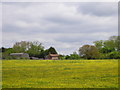
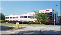
Mercedes Benz, South Marston Park
Part of a large industrial estate on the edge of Swindon.
Image: © Des Blenkinsopp
Taken: 11 Aug 2020
0.09 miles
2

Spitfire Cafe, Hunt's Rise, South Marston Industrial Estate
The name is one of several aeronautical references on this Industrial Estate: an airfield and aircraft factory were here during the Second World War.http://www.swindonweb.com/index.asp?m=8&s=116&ss=402 Hunt's Rise is named after Hunt's Copse Farm, which housed land girls during the war.http://swindonhistory.blogspot.co.uk/2012/09/hunts-copse-farm-south-marston.html The airfield was bought by Honda, whose giant factory now occupies the space.
Image: © Vieve Forward
Taken: 26 Dec 2012
0.10 miles
3
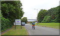
Spitfire Way South Marston Industrial Estate Swindon
This part of Swindon is growing rapidly. The industrial heritage dates back to World War 2 when the Supermarine aircraft company made warplanes here. Some of the road names locally have aircraft connections such as Stirling, Lancaster and Viscount.
Image: © Brian Robert Marshall
Taken: 4 Nov 2006
0.12 miles
4
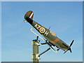
Model Spitfire, Spitfire Way South Marston Swindon
Once upon a time there was a real Spitfire at the entrance to the original industrial complex at South Marston.
Image: © Brian Robert Marshall
Taken: 4 Nov 2006
0.12 miles
5
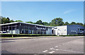
Pentel, South Marston Park
Part of a large industrial estate on the edge of Swindon.
Image: © Des Blenkinsopp
Taken: 11 Aug 2020
0.16 miles
6
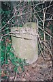
Old Milestone by the A361, Highworth Road, South Marston Park
Swindon half-round stone by the A361, in parish of Stanton Fitzwarren (Swindon District), road beside South Marston Trading Estate, in hedge near lay-by. Broken.
Inscription once read:-
: (Highworth / 2) : : (Swindon / 4) :
Rivet benchmark was on top.
Surveyed
Milestone Society National ID: WI_SNLC04
Image: © Milestone Society
Taken: Unknown
0.17 miles
7
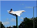
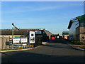
Concorde, Stirling Road, South Marston, Swindon
This part of South Marston is a business park. It was once a wartime aircraft factory and this use continued for some years after 1945. This is a quite realistic-looking model of the Concorde. For another view see http://tinyurl.com/cjd2ffr
Image: © Brian Robert Marshall
Taken: 25 Jun 2008
0.18 miles
8
Concorde, Stirling Road, South Marston, Swindon
This part of South Marston is a business park. It was once a wartime aircraft factory and this use continued for some years after 1945. Although there are no aircraft-related businesses there are aeronautical reminders to be found in road names, a model Spitfire http://www.geograph.org.uk/photo/272713 and this Concorde also seen here http://www.geograph.org.uk/photo/860713
Image: © Brian Robert Marshall
Taken: 25 Jun 2008
0.18 miles