IMAGES TAKEN NEAR TO
Elmore, SWINDON, SN3 3TP
Introduction
This page details the photographs taken nearby to Elmore, SN3 3TP by members of the Geograph project.
The Geograph project started in 2005 with the aim of publishing, organising and preserving representative images for every square kilometre of Great Britain, Ireland and the Isle of Man.

There are currently over 7.5m images from over14,400 individuals and you can help contribute to the project by visiting https://www.geograph.org.uk
Image Map (16 Images)


Getting Data...Please wait
Leaflet Map data © OpenStreetMap
Images are licensed for reuse under creativecommons.org/licenses/by-sa/2.0
Notes
- Clicking on the map will re-center to the selected point.
- The higher the marker number, the further away the image location is from the centre of the postcode.
Image Listing (16 Images Found)
Images are licensed for reuse under creativecommons.org/licenses/by-sa/2.0
Image
Details
Distance
1
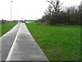
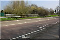
Footpath/cycletrack from Dorcan Way to Eldene Drive, Swindon
The houses in the background are on the northern edge of Eldene, Swindon.
Image: © Brian Robert Marshall
Taken: 7 Jan 2007
0.10 miles
2
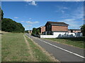
Cycleway and footpath by houses on Elmore
In the Swindon suburb of Eldene.
Image: © Christine Johnstone
Taken: 14 Jul 2022
0.12 miles
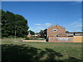
3
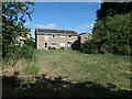
Houses on the west side of Elmore
In the Swindon suburb of Eldene. Seen from a footpath is Shaftesbury Lake Park.
Image: © Christine Johnstone
Taken: 14 Jul 2022
0.13 miles
4
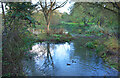
Small Pond on the Dorcan Stream
One of several ponds on this small stream which rises at the base of the Downs to the south of Swindon and flows through the western suburbs to join the River Cole which meets the upper Thames near Lechlade.
Image: © Des Blenkinsopp
Taken: 9 Nov 2022
0.14 miles
5
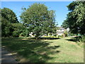
Shaftesbury Lake Park, Eldene, Swindon
The houses facing the park are on a street called Elmore.
Image: © Christine Johnstone
Taken: 14 Jul 2022
0.15 miles
6
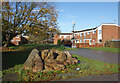
Rocks and Cameras, Islandsmead
In the middle of a district made up of short cul de sacs and terraces all interconnected by a maze of footpaths.
These are all marked on the map, with the result that on some editions this neighbourhood shows up as a sort of green colour because there are so many.
The rocks look like Sarsens, a naturally occurring hard sandstone found on the chalk Downs near here.
Image: © Des Blenkinsopp
Taken: 9 Nov 2022
0.16 miles
8
Eldene Drive, Swindon
Entrance to Bowleymead, off Eldene Drive.
Image: © Vieve Forward
Taken: 28 Dec 2012
0.17 miles
9
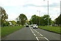
Bridge for Dorcan Way (B4006) over Dorcan Stream
Image: © Roger Templeman
Taken: 9 Apr 2015
0.18 miles
10
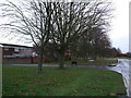
Houses at the northern end of Ecklington
On the edge of Shaftesbury Lake Park, in the Swindon suburb of Eldene.
Image: © Christine Johnstone
Taken: 14 Jul 2022
0.18 miles