IMAGES TAKEN NEAR TO
Dorcan Way, SWINDON, SN3 3RA
Introduction
This page details the photographs taken nearby to Dorcan Way, SN3 3RA by members of the Geograph project.
The Geograph project started in 2005 with the aim of publishing, organising and preserving representative images for every square kilometre of Great Britain, Ireland and the Isle of Man.

There are currently over 7.5m images from over14,400 individuals and you can help contribute to the project by visiting https://www.geograph.org.uk
Image Map (Loading...)


Getting Data...Please wait
Leaflet Map data © OpenStreetMap
Images are licensed for reuse under creativecommons.org/licenses/by-sa/2.0
Notes
- Clicking on the map will re-center to the selected point.
- The higher the marker number, the further away the image location is from the centre of the postcode.
Image Listing (15 Images Found)
Images are licensed for reuse under creativecommons.org/licenses/by-sa/2.0
Image
Details
Distance
1
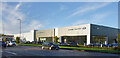
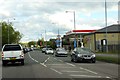
Land Rover & Jaguar Showrooms, Dorcan Way
Vehicle showrooms near the Greenbridge Roundabout.
Image: © Des Blenkinsopp
Taken: 9 Nov 2022
0.01 miles
2
Former Brown Brothers building, Greenbridge, Swindon and the power of Geograph
After many years as an empty shell the building that stood here has now been demolished. This image Image was posted on 3rd January 2007. Coincidence?
Image: © Brian Robert Marshall
Taken: 16 Mar 2007
0.08 miles
3
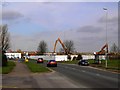
Former Brown Brothers site, Greenbridge, Swindon
First seen in this image Image and secondly here Image the site is now being redeveloped for residential use. The site, when complete, will be known as Dorcan Square reflecting the historical name of the area between Stratton St Margaret and Coate.
Image: © Brian Robert Marshall
Taken: 4 Dec 2007
0.09 miles
4
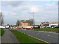
Dorcan Square, Greenbridge, Swindon
This is a follow-up to Image three months on. Marketing of the development has just started; hardly fortuitous timing given the reduction in mortgage availability resulting from the 'credit crunch' caused in large part by the sub-prime mess in America. The project hasn't yet been completed as can be seen at the right of the image.
Image: © Brian Robert Marshall
Taken: 3 Apr 2008
0.10 miles
5
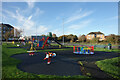
Play Area, Dorcan Way
At the top end of a recreation ground on the south side of Dorcan Way.
Image: © Des Blenkinsopp
Taken: 9 Nov 2022
0.11 miles
6
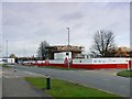
Former Brown Brothers building, Greenbridge, Swindon
A bit of a blot on the landscape, the building has been empty for several years. Since this photo was taken, further deterioration has occurred. The problem seems to be that the building cannot be adapted for modern needs. Whatever the reasons for its decrepitude, it's time to accept the inevitable and knock it down.
Image: © Brian Robert Marshall
Taken: 10 Nov 2006
0.11 miles
8
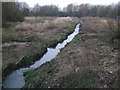
River Cole, near Greenbridge
The River Cole emerges from the bowels of Swindon not far from here and runs through this scruffy patch of wilderness out of sight of the nearby Greenbridge Trading Estate, the WHSmith headquarters, and the Covingham housing estate. It flows out of Swindon and via Coleshill to join the Thames just below Lechlade.
Image: © Vieve Forward
Taken: 22 Mar 2013
0.14 miles
9
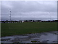
Rugby pitch, Greenbridge Road, Swindon
Playing fields of Swindon Rugby Football Club. The houses of Nythe estate can be seen in the background.
Image: © Vieve Forward
Taken: 28 Dec 2012
0.19 miles
10
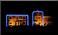
New houses, Oakley Park, Swindon
I believe these are the show homes for this new development that does not yet appear on the OS maps, but does on Google Earth. Lit up for Yuletide with perhaps a little more restraint than some others.
Image: © Brian Robert Marshall
Taken: 8 Dec 2007
0.20 miles