IMAGES TAKEN NEAR TO
Frobisher Drive, SWINDON, SN3 3HB
Introduction
This page details the photographs taken nearby to Frobisher Drive, SN3 3HB by members of the Geograph project.
The Geograph project started in 2005 with the aim of publishing, organising and preserving representative images for every square kilometre of Great Britain, Ireland and the Isle of Man.

There are currently over 7.5m images from over14,400 individuals and you can help contribute to the project by visiting https://www.geograph.org.uk
Image Map (Loading...)


Getting Data...Please wait
Leaflet Map data © OpenStreetMap
Images are licensed for reuse under creativecommons.org/licenses/by-sa/2.0
Notes
- Clicking on the map will re-center to the selected point.
- The higher the marker number, the further away the image location is from the centre of the postcode.
Image Listing (24 Images Found)
Images are licensed for reuse under creativecommons.org/licenses/by-sa/2.0
Image
Details
Distance
1
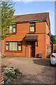
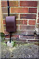
#32 Marlowe Avenue
There is an OS benchmark Image on the front of the house at the left hand corner
Image: © Roger Templeman
Taken: 13 Apr 2015
0.06 miles
2
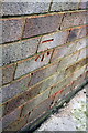
Benchmark on #32 Marlowe Avenue
Ordnance Survey cut mark benchmark described on the Bench Mark Database at http://www.bench-marks.org.uk/bm55681
Image: © Roger Templeman
Taken: 13 Apr 2015
0.07 miles
3
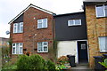
#130 Drake's Way
There is an OS benchmark Image on the front of the house near the left hand corner.
Image: © Roger Templeman
Taken: 13 Apr 2015
0.10 miles
4
Benchmark on #130 Drake's Way
Ordnance Survey cut mark benchmark described on the Bench Mark Database at http://www.bench-marks.org.uk/bm65908
Image: © Roger Templeman
Taken: 13 Apr 2015
0.10 miles
5

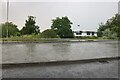
Former EMI CD factory, Penny Lane, Swindon
EMI had several operations in Swindon at one time. This plant was built by them in the 1990s to replace a smaller factory in Greenbridge. Then they found that it was cheaper to manufacture CDs in Holland so they closed the factory about six years ago. It has recently been sold to a car retailer. The name 'Penny Lane' is derived from a song by a now defunct pop group.
Image: © Brian Robert Marshall
Taken: 24 Feb 2007
0.14 miles
7
Benchmark on 29 Dacre Road
Ordnance Survey cut mark benchmark described on the Bench Mark Database at http://www.bench-marks.org.uk/bm55682
Image: © Roger Templeman
Taken: 13 Apr 2015
0.16 miles
8
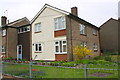
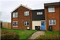
Housing on Dacre Road
There is an OS benchmark Image on the corner (right hand face) of the near house
Image: © Roger Templeman
Taken: 13 Apr 2015
0.16 miles
9
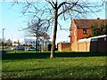
View from Fairfax Close, Walcot, Swindon
Fairfax Close is named after a famous Elizabethan or someone from that era. Most of the road names in Walcot commemorate such figures. The only Fairfax I could find who fits the requirements is Ferdinando Fairfax, 2nd Lord Fairfax of Cameron http://en.wikipedia.org/wiki/Ferdinando_Fairfax,_2nd_Lord_Fairfax_of_Cameron who was only 19 when Elizabeth I died and became more famous in the age of Charles I. The houses visible here are in Drakes Way, yet another well-known Elizabethan.
NOTE. This image has a detailed ‘shared description’ which you won’t see by viewing this image on a slideshow. To read it click on the image.
Image: © Brian Robert Marshall
Taken: 2 Jan 2010
0.17 miles