IMAGES TAKEN NEAR TO
Lennox Drive, SWINDON, SN3 3AX
Introduction
This page details the photographs taken nearby to Lennox Drive, SN3 3AX by members of the Geograph project.
The Geograph project started in 2005 with the aim of publishing, organising and preserving representative images for every square kilometre of Great Britain, Ireland and the Isle of Man.

There are currently over 7.5m images from over14,400 individuals and you can help contribute to the project by visiting https://www.geograph.org.uk
Image Map (Loading...)


Getting Data...Please wait
Leaflet Map data © OpenStreetMap
Images are licensed for reuse under creativecommons.org/licenses/by-sa/2.0
Notes
- Clicking on the map will re-center to the selected point.
- The higher the marker number, the further away the image location is from the centre of the postcode.
Image Listing (37 Images Found)
Images are licensed for reuse under creativecommons.org/licenses/by-sa/2.0
Image
Details
Distance
1
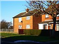
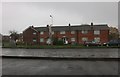
Houses in Raleigh Avenue, Walcot, Swindon
Raleigh Avenue is named after Sir Walter Raleigh, the famous Elizabethan who discovered tobacco and potatoes. Despite these accomplishments he was beheaded in 1618 because some Spaniard demanded it http://en.wikipedia.org/wiki/Walter_Raleigh Although most of the estate was intended for Londoners displaced from the capital in the post-war years, occasionally others were allocated homes here. The house at the right was occupied by the photographer from 1956 to 1962 when his father moved to the town from the Midlands to take up a new job in the town.
NOTE. This image has a detailed ‘shared description’ which you won’t see by viewing this image on a slideshow. To read it click on the image.
Image: © Brian Robert Marshall
Taken: 2 Jan 2010
0.07 miles
2
Shirley Close, Walcot, Swindon
There is almost certainly a famous Elizabethan behind the road name however I'm not sure who at present. Shirley Close joins Frobisher Drive named after Martin Frobisher Image
NOTE. This image has a detailed ‘shared description’ which you won’t see by viewing this image on a slideshow. To read it click on the image.
Image: © Brian Robert Marshall
Taken: 2 Jan 2010
0.08 miles
3
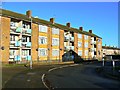
Flats, Somerville Road, Walcot, Swindon
Somerville Road is named after a famous Elizabethan as are most of the roads in Walcot. The estate comprises a mix of terraced houses and maisonettes.
NOTE. This image has a detailed ‘shared description’ which you won’t see by viewing this image on a slideshow. To read it click on the image.
Image: © Brian Robert Marshall
Taken: 2 Jan 2010
0.09 miles
4
Terrace of houses on Drakes Way, Swindon
These were probably from around the 50s and built by the local authority going by the basic design.
Image: © David Howard
Taken: 26 Oct 2019
0.09 miles
5
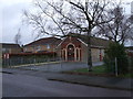
St. Andrew's Church Centre, Raleigh Avenue, Walcot
The building to the left is Harry Edwards Court, a Salvation Army Housing Association property.
Image: © Vieve Forward
Taken: 28 Dec 2012
0.11 miles
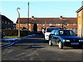
6
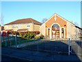
St Andrew's Church Centre, Raleigh Avenue, Walcot
The building seen here at the right was originally used as the church hall for St Andrew's church which once stood where the maisonettes can be seen at the left. Unfortunately the original church had to be demolished for structural reasons.
NOTE. This image has a detailed ‘shared description’ which you won’t see by viewing this image on a slideshow. To read it click on the image.
Image: © Brian Robert Marshall
Taken: 2 Jan 2010
0.11 miles
7
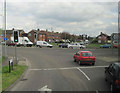
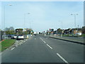
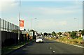
Junction of Ocotal Way and Drakes Way Swindon
Image: © John Firth
Taken: 10 May 2010
0.12 miles
8
Drake's Way in Swindon
Drake's Way leads to the A420 out of Swindon.
Image: © Steve Daniels
Taken: 25 Jun 2014
0.13 miles
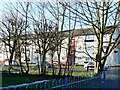
9
Sussex Square, Walcot East, Swindon (5 of 7)
Sussex Square opened in the late 1950s as a mix of residential accommodation and retail outlets including a newsagent, two grocers, a greengrocer and a fish and chip shop. There was also a 'Common Room' (a community hall) with a branch lending library. I seem to recall that there was also a launderette. The square has had its day and is scheduled to be demolished and redeveloped. More below...
Image: © Brian Robert Marshall
Taken: 2 Jan 2014
0.13 miles