IMAGES TAKEN NEAR TO
Blandford Court, SWINDON, SN3 2PP
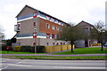
Introduction
This page details the photographs taken nearby to Blandford Court, SN3 2PP by members of the Geograph project.
The Geograph project started in 2005 with the aim of publishing, organising and preserving representative images for every square kilometre of Great Britain, Ireland and the Isle of Man.

There are currently over 7.5m images from over14,400 individuals and you can help contribute to the project by visiting https://www.geograph.org.uk
Image Map
Images are licensed for reuse under creativecommons.org/licenses/by-sa/2.0
Notes
- Clicking on the map will re-center to the selected point.
- The higher the marker number, the further away the image location is from the centre of the postcode.
Image Listing (17 Images Found)
Images are licensed for reuse under creativecommons.org/licenses/by-sa/2.0
Image
Details
Distance
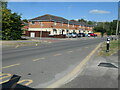
1
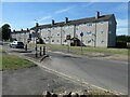
'Give way to oncoming vehicles' in Marlowe Avenue
Traffic calming measures in Swindon's suburb of Park North. The nearer block of walk-up flats is in Marlowe Avenue, the further one in Ringwood Close.
Image: © Christine Johnstone
Taken: 14 Jul 2022
0.06 miles
2
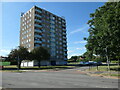
Hatherleigh Court, Ringwood Close, Park North
The only high-rise flats in this part of Swindon.
Image: © Christine Johnstone
Taken: 14 Jul 2022
0.07 miles
3
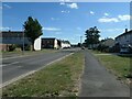
Welcombe Avenue, Park North, Swindon
Looking south from the junction with Marlowe Avenue.
Image: © Christine Johnstone
Taken: 14 Jul 2022
0.10 miles
4
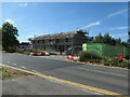
Building site, off Marlowe Avenue, Park North
New housing on what appears to have been open land.
Image: © Christine Johnstone
Taken: 14 Jul 2022
0.10 miles
5
George Selman Gardens, Marlowe Avenue
Image: © Roger Templeman
Taken: 13 Apr 2015
0.11 miles
6
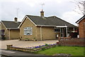
#18 Chalford Avenue
There is an OS benchmark Image on the near corner, right hand face, of the bungalow
Image: © Roger Templeman
Taken: 13 Apr 2015
0.13 miles
7
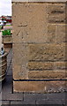
Benchmark on #18 Chalford Avenue
Ordnance Survey cut mark benchmark described on the Bench Mark Database at http://www.bench-marks.org.uk/bm65909
Image: © Roger Templeman
Taken: 13 Apr 2015
0.13 miles
8
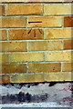
Benchmark on #2 Bentley Close
Ordnance Survey cut mark benchmark described on the Bench Mark Database at http://www.bench-marks.org.uk/bm66080
Image: © Roger Templeman
Taken: 13 Apr 2015
0.15 miles
9
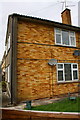
Nos. 2 and 4 Bentley Close
There is an OS benchmark Image on the bricks of the house wall about 3 feet from the left hand corner
Image: © Roger Templeman
Taken: 13 Apr 2015
0.15 miles
10
Old School Court, off Marlowe Avenue, Park North
New housing built between the Holy Family Rpman Catholic primary school and the Holy Family Catholic Church. Presumably built on the old site of the school
Image: © Christine Johnstone
Taken: 14 Jul 2022
0.16 miles