IMAGES TAKEN NEAR TO
Welcombe Avenue, SWINDON, SN3 2PE
Introduction
This page details the photographs taken nearby to Welcombe Avenue, SN3 2PE by members of the Geograph project.
The Geograph project started in 2005 with the aim of publishing, organising and preserving representative images for every square kilometre of Great Britain, Ireland and the Isle of Man.

There are currently over 7.5m images from over14,400 individuals and you can help contribute to the project by visiting https://www.geograph.org.uk
Image Map (Loading...)


Getting Data...Please wait
Leaflet Map data © OpenStreetMap
Images are licensed for reuse under creativecommons.org/licenses/by-sa/2.0
Notes
- Clicking on the map will re-center to the selected point.
- The higher the marker number, the further away the image location is from the centre of the postcode.
Image Listing (20 Images Found)
Images are licensed for reuse under creativecommons.org/licenses/by-sa/2.0
Image
Details
Distance
1
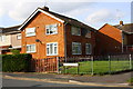
Houses at junction of Honiton Road and Shaftesbury Avenue
There is an OS benchmark Image on the near corner of the house, right of its grey downpipe
Image: © Roger Templeman
Taken: 13 Apr 2015
0.10 miles
2
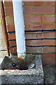
Benchmark on #19 Honiton Road
Ordnance Survey cut mark benchmark described on the Bench Mark Database at http://www.bench-marks.org.uk/bm66419
Image: © Roger Templeman
Taken: 13 Apr 2015
0.10 miles
3
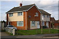
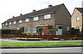
Nos. 215 and 217 Whitbourne Avenue
There is an OS benchmark Image on the near corner of the house, right of the white downpipe.
Image: © Roger Templeman
Taken: 13 Apr 2015
0.11 miles
4
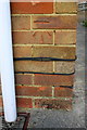
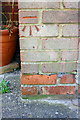
Benchmark on #215 Whitbourne Avenue
Ordnance Survey cut mark benchmark described on the Bench Mark Database at http://www.bench-marks.org.uk/bm66195
Image: © Roger Templeman
Taken: 13 Apr 2015
0.11 miles
5
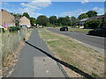
Whitbourne Avenue, Park South, Swindon
Heading east to a T junction with the estate's perimeter road.
Image: © Christine Johnstone
Taken: 14 Jul 2022
0.12 miles
6
Row of houses on Whitbourne Avenue seen across Shaftesbury Avenue
There is an OS benchmark Image on the corner of the near house left of its white door.
Image: © Roger Templeman
Taken: 13 Apr 2015
0.12 miles
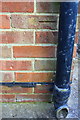
7
Benchmark on #245 Whitbourne Avenue
Ordnance Survey cut mark benchmark described on the Bench Mark Database at http://www.bench-marks.org.uk/bm66093
Image: © Roger Templeman
Taken: 13 Apr 2015
0.12 miles
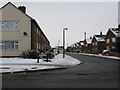
8
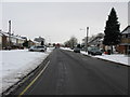
Looking W along Whitbourne Avenue, Swindon
Image: © Nick Smith
Taken: 23 Dec 2010
0.14 miles
9
Bridport Road off Whitbourne Avenue, Swindon
Image: © Nick Smith
Taken: 23 Dec 2010
0.15 miles
10
Benchmark on #155 Whitbourne Avenue
Ordnance Survey cut mark benchmark described on the Bench Mark Database at http://www.bench-marks.org.uk/bm66196
Image: © Roger Templeman
Taken: 13 Apr 2015
0.16 miles