IMAGES TAKEN NEAR TO
Welcombe Avenue, SWINDON, SN3 2PD
Introduction
This page details the photographs taken nearby to Welcombe Avenue, SN3 2PD by members of the Geograph project.
The Geograph project started in 2005 with the aim of publishing, organising and preserving representative images for every square kilometre of Great Britain, Ireland and the Isle of Man.

There are currently over 7.5m images from over14,400 individuals and you can help contribute to the project by visiting https://www.geograph.org.uk
Image Map
Images are licensed for reuse under creativecommons.org/licenses/by-sa/2.0
Notes
- Clicking on the map will re-center to the selected point.
- The higher the marker number, the further away the image location is from the centre of the postcode.
Image Listing (19 Images Found)
Images are licensed for reuse under creativecommons.org/licenses/by-sa/2.0
Image
Details
Distance
1
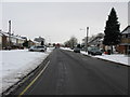
Bridport Road off Whitbourne Avenue, Swindon
Image: © Nick Smith
Taken: 23 Dec 2010
0.08 miles
2
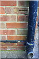
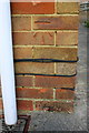
Benchmark on #155 Whitbourne Avenue
Ordnance Survey cut mark benchmark described on the Bench Mark Database at http://www.bench-marks.org.uk/bm66196
Image: © Roger Templeman
Taken: 13 Apr 2015
0.09 miles
3
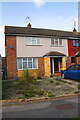
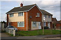
#155 Whitbourne Avenue
There is an OS benchmark Image on the side of the house at the left hand corner
Image: © Roger Templeman
Taken: 13 Apr 2015
0.09 miles
4
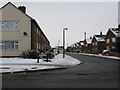
Looking W along Whitbourne Avenue, Swindon
Image: © Nick Smith
Taken: 23 Dec 2010
0.10 miles
5
Benchmark on #215 Whitbourne Avenue
Ordnance Survey cut mark benchmark described on the Bench Mark Database at http://www.bench-marks.org.uk/bm66195
Image: © Roger Templeman
Taken: 13 Apr 2015
0.11 miles
6
Nos. 215 and 217 Whitbourne Avenue
There is an OS benchmark Image on the near corner of the house, right of the white downpipe.
Image: © Roger Templeman
Taken: 13 Apr 2015
0.11 miles
7
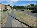
Whitbourne Avenue, Park South, Swindon
Heading east to a T junction with the estate's perimeter road.
Image: © Christine Johnstone
Taken: 14 Jul 2022
0.13 miles
8
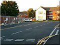
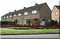
Royston Road, Park South, Swindon
Royston Road is in the foreground. It joins Whitbourne Avenue at the T junction in the background. Park South is a municipal housing estate built in the late 1950s and early 1960s. Whitbourne Avenue marks the boundary between Park South and its neighbouring estate Park North developed a little later.
Image: © Brian Robert Marshall
Taken: 12 Oct 2008
0.15 miles
9
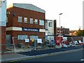
Cock Robin, Cavendish Square, Park South, Swindon
Park South is a large municipal housing estate that was built in the late 1950s and early 1960s. A feature of the estate is a medium-sized centre comprising shops, flats, a library and a pub. The architects who designed it won some sort of award although, in practice, it turned out to be a rather grim place, particularly at night. It is now in the process of being comprehensively improved. The Cock Robin pub was a real dive and its passing will cause little sadness. The pub and the building next to it are I think due to be demolished.
Image: © Brian Robert Marshall
Taken: 12 Oct 2008
0.15 miles
10
Row of houses on Whitbourne Avenue seen across Shaftesbury Avenue
There is an OS benchmark Image on the corner of the near house left of its white door.
Image: © Roger Templeman
Taken: 13 Apr 2015
0.16 miles