IMAGES TAKEN NEAR TO
Whitbourne Avenue, SWINDON, SN3 2LG
Introduction
This page details the photographs taken nearby to Whitbourne Avenue, SN3 2LG by members of the Geograph project.
The Geograph project started in 2005 with the aim of publishing, organising and preserving representative images for every square kilometre of Great Britain, Ireland and the Isle of Man.

There are currently over 7.5m images from over14,400 individuals and you can help contribute to the project by visiting https://www.geograph.org.uk
Image Map (Loading...)


Getting Data...Please wait
Leaflet Map data © OpenStreetMap
Images are licensed for reuse under creativecommons.org/licenses/by-sa/2.0
Notes
- Clicking on the map will re-center to the selected point.
- The higher the marker number, the further away the image location is from the centre of the postcode.
Image Listing (22 Images Found)
Images are licensed for reuse under creativecommons.org/licenses/by-sa/2.0
Image
Details
Distance
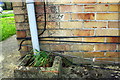
1
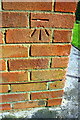
Benchmark on #117 Whitbourne Avenue
Ordnance Survey cut mark benchmark described on the Bench Mark Database at http://www.bench-marks.org.uk/bm66197
Image: © Roger Templeman
Taken: 13 Apr 2015
0.05 miles
2
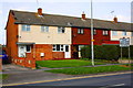
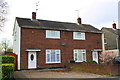
Row of houses on Whitbourne Avenue
There is an OS benchmark Image on the side of the left hand house near its front corner
Image: © Roger Templeman
Taken: 13 Apr 2015
0.05 miles
4
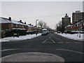
Kingswood Avenue from Whitbourne Avenue, Swindon
Image: © Nick Smith
Taken: 23 Dec 2010
0.11 miles
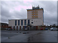
5
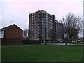
Torrington Court and Milverton Court, Park North
Multi-storey blocks of council flats built in the 1960s.
Image: © Vieve Forward
Taken: 28 Dec 2012
0.11 miles
6
Benchmark on #34 Cranmore Avenue
Ordnance Survey cut mark benchmark described on the Bench Mark Database at http://www.bench-marks.org.uk/bm66084
Image: © Roger Templeman
Taken: 13 Apr 2015
0.12 miles
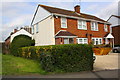
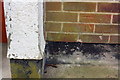
7
Nos. 34 and 32 Cranmore Avenue
There is an OS benchmark Image on the front of the left hand house, left of its front door.
Image: © Roger Templeman
Taken: 13 Apr 2015
0.12 miles
8
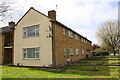
Apartments on Kingswood Avenue
There is an OS benchmark Image on the near corner of the block, right hand face, right of the downpipe
Image: © Roger Templeman
Taken: 13 Apr 2015
0.14 miles
9
Benchmark on #164 Kingswood Avenue
Ordnance Survey cut mark benchmark described on the Bench Mark Database at http://www.bench-marks.org.uk/bm66083
Image: © Roger Templeman
Taken: 13 Apr 2015
0.14 miles
10
Block of flats, Cavendish Square, Park
Refurbished 1960s block of flats, Cavendish Square. At its base is Park Library and a number of community services, including a credit union.
Image: © Vieve Forward
Taken: 28 Dec 2012
0.15 miles