IMAGES TAKEN NEAR TO
Bouverie Avenue, SWINDON, SN3 1PZ
Introduction
This page details the photographs taken nearby to Bouverie Avenue, SN3 1PZ by members of the Geograph project.
The Geograph project started in 2005 with the aim of publishing, organising and preserving representative images for every square kilometre of Great Britain, Ireland and the Isle of Man.

There are currently over 7.5m images from over14,400 individuals and you can help contribute to the project by visiting https://www.geograph.org.uk
Image Map
Images are licensed for reuse under creativecommons.org/licenses/by-sa/2.0
Notes
- Clicking on the map will re-center to the selected point.
- The higher the marker number, the further away the image location is from the centre of the postcode.
Image Listing (140 Images Found)
Images are licensed for reuse under creativecommons.org/licenses/by-sa/2.0
Image
Details
Distance
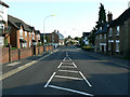
1
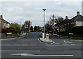
Carlisle Avenue, Swindon
Viewed across Marlborough Road.
Image: © Jaggery
Taken: 14 Apr 2013
0.07 miles
2
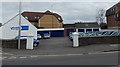
Lakeside Garage, Swindon
Car sales business located in The Old Stables, on the corner of Marlborough Road and Old Mill Lane.
Image: © Jaggery
Taken: 14 Apr 2013
0.07 miles
3
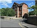
1 - 12 Mill Court, Old Mill Lane, Swindon
Where and what was the 'old mill'?
Image: © Christine Johnstone
Taken: 14 Jul 2022
0.08 miles
4
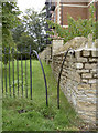
Squeeze through
An unusual form of stile by the new residential development Mill Court. Not well marked, it is a footpath.
Image: © Neil Owen
Taken: 4 Sep 2014
0.09 miles
5
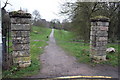
Old Mill Lane and The Lawn park in winter
This is the end of Old Mill Lane. It continues around the corner on the left, but that section is known as The Planks. Ahead the two gate posts mark one of the entrances to The Lawn. Originally this was the home of the Goddard family, who were lords of the manor. The house was demolished in the 1950's. The grounds are now a public park, owned by Swindon Borough Council.
Image: © P L Chadwick
Taken: Unknown
0.09 miles
6
View across Marlborough Road from a former railway bridge, Swindon
Viewed from here http://www.geograph.org.uk/photo/3851186 looking towards Carlisle Avenue across Marlborough Road.
Evelyn Street is in the foreground.
Image: © Jaggery
Taken: 14 Apr 2013
0.10 miles
7
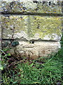
Benchmark on gatepost at entrance to The Lawn
Ordnance Survey cut mark benchmark described on the Bench Mark Database at http://www.bench-marks.org.uk/bm37345
Image: © Roger Templeman
Taken: 18 Mar 2011
0.10 miles
8
Gateposts at the entrance to The Lawn park
There is a benchmark Image at the base of the left hand side gatepost
Image: © Roger Templeman
Taken: 18 Mar 2011
0.10 miles
9
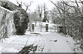
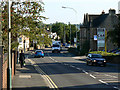
South along Marlborough Road, Swindon
Marlborough Road was and remains one of the main routes to and from the town. However its character here has changed over the last ten to fifteen years. At the left is fairly new housing, Mill Court. Beyond that the building with the mansard roof is Ashlar Court. Both developments cater, I think, mainly for retired people. Before this development occurred there was a large car dealership here called Greens who held the Chrysler franchise for a while. The cottages on the right are relatively old, early 19th century. They are within the Old Town conservation area and are listed http://www.imagesofengland.org.uk/details/default.aspx?id=318785
Image: © Brian Robert Marshall
Taken: 10 Sep 2009
0.10 miles
10
Marlborough Road, Swindon
The imposing building on the right behind the advertising board was once, I believe, occupied by a prominent veterinary surgeon. Then it became the offices of a car dealership. The dealership vacated the site some years ago and re-located. Since then the building has been left unoccupied.
Image: © Brian Robert Marshall
Taken: 10 Sep 2009
0.10 miles