IMAGES TAKEN NEAR TO
Marlborough Road, SWINDON, SN3 1NP
Introduction
This page details the photographs taken nearby to Marlborough Road, SN3 1NP by members of the Geograph project.
The Geograph project started in 2005 with the aim of publishing, organising and preserving representative images for every square kilometre of Great Britain, Ireland and the Isle of Man.

There are currently over 7.5m images from over14,400 individuals and you can help contribute to the project by visiting https://www.geograph.org.uk
Image Map
Images are licensed for reuse under creativecommons.org/licenses/by-sa/2.0
Notes
- Clicking on the map will re-center to the selected point.
- The higher the marker number, the further away the image location is from the centre of the postcode.
Image Listing (18 Images Found)
Images are licensed for reuse under creativecommons.org/licenses/by-sa/2.0
Image
Details
Distance
1
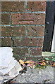
Benchmark on garage of #340 Marlborough Road
Ordnance Survey cut mark benchmark described on the Bench Mark Database at http://www.bench-marks.org.uk/bm66426
Image: © Roger Templeman
Taken: 22 Apr 2015
0.02 miles
2
#340 Marlborough Road with attached garage
There is an OS benchmark Image on the bricks on the right hand side of the garage door.
Image: © Roger Templeman
Taken: 22 Apr 2015
0.02 miles
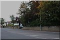
5

B4006 Marlborough Road, Swindon
Towards the Old Town.
Image: © Robin Webster
Taken: 19 Jan 2020
0.06 miles
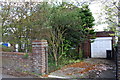
6
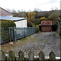
Thames Water enclosure, Lawn, Swindon
On the south side of Marlborough Road in the Lawn area of Swindon.
One map shows that the building is a pump house.
Image: © Jaggery
Taken: 14 Apr 2013
0.07 miles
7
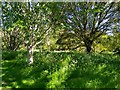
Trees and cow parsley, Coate Remembrance Wood, Coate Water, Swindon
The remembrance park has a fairly wide range of trees within in, most no more than between twenty and thirty years old.
Image: © Brian Robert Marshall
Taken: 14 May 2020
0.12 miles
8
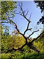
Dead tree, Coate Remembrance Wood, Coate Water, Swindon
This was the only dead tree immediately apparent in the remembrance wood. All the others appeared to be in good health. The wood is a fairly recent development going back to the late 20th century.
Image: © Brian Robert Marshall
Taken: 14 May 2020
0.12 miles
9

Oak tree, Coate Remembrance Wood, Coate Water, Swindon
The remembrance park is a late 19th century development on the edge of the much older country park. This oak tree may date back to the 19th century.
Image: © Brian Robert Marshall
Taken: 14 May 2020
0.13 miles
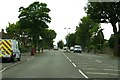
10
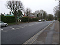
Marlborough Road, Swindon
Busy main road lined with large houses, semis and bungalows. The house on the left has a very distinctive green-tiled roof. The large building beyond is a care home. There is a petrol station further down on the right.
Image: © Vieve Forward
Taken: 2 Jan 2013
0.15 miles