IMAGES TAKEN NEAR TO
Brettingham Gate, SWINDON, SN3 1NH
Introduction
This page details the photographs taken nearby to Brettingham Gate, SN3 1NH by members of the Geograph project.
The Geograph project started in 2005 with the aim of publishing, organising and preserving representative images for every square kilometre of Great Britain, Ireland and the Isle of Man.

There are currently over 7.5m images from over14,400 individuals and you can help contribute to the project by visiting https://www.geograph.org.uk
Image Map (Loading...)


Getting Data...Please wait
Leaflet Map data © OpenStreetMap
Images are licensed for reuse under creativecommons.org/licenses/by-sa/2.0
Notes
- Clicking on the map will re-center to the selected point.
- The higher the marker number, the further away the image location is from the centre of the postcode.
Image Listing (20 Images Found)
Images are licensed for reuse under creativecommons.org/licenses/by-sa/2.0
Image
Details
Distance
1
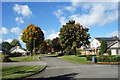
Brettingham Gate, Swindon
Right on the edge of built-up Swindon, SU1681 is largely non residential. The short, tree lined roads of Brettingham Gate in the north east corner are the exception.
Image: © Des Blenkinsopp
Taken: 10 Oct 2022
0.01 miles
2
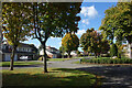
Trees and Houses, Brettingham Gate
Brettingham Gate is a pleasant tree lined development right on the edge (so far) of built-up Swindon.
With a golf course on three sides, it might stay that way for some time.
Image: © Des Blenkinsopp
Taken: 10 Oct 2022
0.05 miles
3
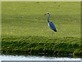
Heron, Broome Manor golf course, Swindon
This haughty bird was waiting by a water hazard, presumably hoping for a quick snack. I don't know if there are any fish in the hazard. I do know there's at least one golf ball. I saw it go in.
Image: © Brian Robert Marshall
Taken: 12 Mar 2008
0.12 miles
4
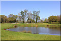
Broome Manor Golf Course
View of the lake at the course.
Image: © Wayland Smith
Taken: 13 Apr 2020
0.12 miles
5
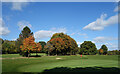
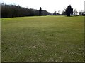
Part of Broome Manor Golf Course
The golf course on the edge of town plus the adjacent Coate Water Country Park are preventing suburban Swindon filling in some of the open space north of the M4.
Image: © Des Blenkinsopp
Taken: 10 Oct 2022
0.15 miles
6
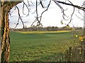
Broome Manor Golf Course
This view shows just a small section of Broome Manor Golf Course, which is owned by Swindon Borough Council, and is a very popular course. The course is part of what is called the Broome Manor Golf Complex and comprises both an 18 hole and a 9 hole course, a driving range, a clubhouse & other facilities.
http://www.bmgc.co.uk/indexpl.htm
Image: © P L Chadwick
Taken: 11 Dec 2008
0.19 miles
7
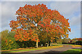
Broome Manor Lane
Display of autumnal colour in Swindon.
Image: © Wayland Smith
Taken: 27 Oct 2013
0.21 miles
8
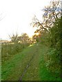
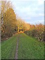
Path from Broome Manor Lane to Broome Manor Golf Complex
The local Council, who own the golf course, allow the public to use this path which runs alongside the course. This view is looking in the direction of the Club House.
Image: © P L Chadwick
Taken: 11 Dec 2008
0.21 miles
9
Broome Manor golf course, Swindon
This is a view to the south-west along the tenth hole from the tee towards the pin (out of sight) in the next square south. Par 4, 308 yards (281 metres).
Image: © Brian Robert Marshall
Taken: 12 Mar 2008
0.21 miles
10
Path adjacent to Broome Manor Golf Course
The Council, who own this land, allow the public to use this footpath. Looking in the direction of Broome Manor Lane. See also Image and Image
Image: © P L Chadwick
Taken: 11 Dec 2008
0.21 miles