IMAGES TAKEN NEAR TO
Broughton Grange, SWINDON, SN3 1LW
Introduction
This page details the photographs taken nearby to Broughton Grange, SN3 1LW by members of the Geograph project.
The Geograph project started in 2005 with the aim of publishing, organising and preserving representative images for every square kilometre of Great Britain, Ireland and the Isle of Man.

There are currently over 7.5m images from over14,400 individuals and you can help contribute to the project by visiting https://www.geograph.org.uk
Image Map
Images are licensed for reuse under creativecommons.org/licenses/by-sa/2.0
Notes
- Clicking on the map will re-center to the selected point.
- The higher the marker number, the further away the image location is from the centre of the postcode.
Image Listing (57 Images Found)
Images are licensed for reuse under creativecommons.org/licenses/by-sa/2.0
Image
Details
Distance
2
Redevelopment of George Gay Gardens, Queens Drive, Swindon (11)
Six months on from this one https://www.geograph.org.uk/photo/6794573 and completion of the development is on the horizon.
Image: © Brian Robert Marshall
Taken: 7 Sep 2021
0.04 miles
3
Redevelopment of George Gay Gardens, Queens Drive, Swindon (4)
Compare with Image from 2019 when site clearance was well advanced.
Image: © Brian Robert Marshall
Taken: 17 Dec 2020
0.04 miles
4
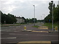
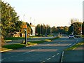
Queens Drive, Swindon
Queens Drive is a relatively modern road as it was only built within the last fifty years as part of the post-war expansion of south-east Swindon. It is subject to a 40 mph speed limit that was until recently monitored by a Gatso camera, visible at the left of the image. Because of local politics some but not all of the cameras have been taken out of service, like this one. More on the issues here http://news.bbc.co.uk/1/hi/england/wiltshire/7506689.stm
Image: © Brian Robert Marshall
Taken: 19 Jul 2008
0.04 miles
5
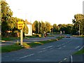
Queens Drive, Swindon
The static speed camera in this image http://www.geograph.org.uk/photo/889453 is back in use so take care. Note also that the Police are in the habit of siting a mobile speed trap around the bend in the distance to catch the brain-deads who welly it after passing the Gatso.
Whether it will stay in use remains to be seen http://news.bbc.co.uk/1/hi/england/wiltshire/7669100.stm
Image: © Brian Robert Marshall
Taken: 12 Oct 2008
0.04 miles
6
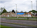
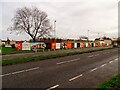
George Gay Gardens, Queens Drive, Swindon (14)
At left is a pile of crushed rubble. In time this will be taken off site and used for hardcore perhaps in a road-building project somewhere.
Image: © Brian Robert Marshall
Taken: 5 May 2019
0.04 miles
7
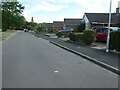
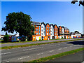
Bungalows on Cambridge Close, Swindon
Built after 1945.
Image: © Christine Johnstone
Taken: 14 Jul 2022
0.04 miles
8
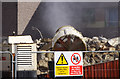
George Gay Gardens, Queens Drive, Swindon (10)
This is a closer view of the fan-assisted water-spray used to control the dust inevitably produced during the demolition process.
Image: © Brian Robert Marshall
Taken: 10 Apr 2019
0.04 miles
9
Redevelopment of George Gay Gardens, Queens Drive, Swindon (7)
Considerable progress has been made on this development since December 2020 https://www.geograph.org.uk/photo/6706891
Image: © Brian Robert Marshall
Taken: 1 Apr 2021
0.05 miles
10
Redevelopment of George Gay Gardens, Queens Drive, Swindon (8)
The redevelopment has been progressing well since December 2020 https://www.geograph.org.uk/photo/6706854
Image: © Brian Robert Marshall
Taken: 1 Apr 2021
0.05 miles