IMAGES TAKEN NEAR TO
Orpen Close, SWINDON, SN3 1FR
Introduction
This page details the photographs taken nearby to Orpen Close, SN3 1FR by members of the Geograph project.
The Geograph project started in 2005 with the aim of publishing, organising and preserving representative images for every square kilometre of Great Britain, Ireland and the Isle of Man.

There are currently over 7.5m images from over14,400 individuals and you can help contribute to the project by visiting https://www.geograph.org.uk
Image Map
Images are licensed for reuse under creativecommons.org/licenses/by-sa/2.0
Notes
- Clicking on the map will re-center to the selected point.
- The higher the marker number, the further away the image location is from the centre of the postcode.
Image Listing (35 Images Found)
Images are licensed for reuse under creativecommons.org/licenses/by-sa/2.0
Image
Details
Distance
1

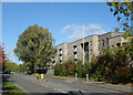
Hello Show Suite
Marketing new apartments.
Looking along Hayman Crescent from Lowry Way.
Image: © Des Blenkinsopp
Taken: 10 Oct 2022
0.02 miles
4

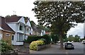
B4006 Marlborough Road, Swindon
Towards the Old Town.
Image: © Robin Webster
Taken: 19 Jan 2020
0.08 miles
6
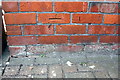
Benchmark on #186 Marlborough Road
Ordnance Survey cut mark benchmark described on the Bench Mark Database at http://www.bench-marks.org.uk/bm66428
Image: © Roger Templeman
Taken: 22 Apr 2015
0.10 miles
7
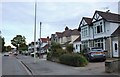
Pipers Way at Aspect Park
A main road in the outer suburbs of Swindon, Pipers Way, aka B4006, loops around an area of offices, new apartments and as yet undeveloped woodland.
Image: © Des Blenkinsopp
Taken: 10 Oct 2022
0.10 miles
8
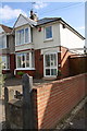
#186 Marlborough Road
There is an OS benchmark Image on the right hand side of the house near the front corner
Image: © Roger Templeman
Taken: 22 Apr 2015
0.10 miles
9
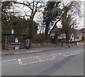
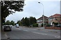
Marlborough Road bus shelter, Swindon
Viewed across the B4006 Marlborough Road. Signs show that this is the way
to the M4 motorway and a hospital with an A&E (Accident & Emergency) department.
Image: © Jaggery
Taken: 14 Apr 2013
0.11 miles
10
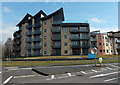
Recently-built apartments in Swindon
Viewed across the northern end of Pipers Way in April 2013. Some online maps are still showing only green fields here at the mid February 2014 date of this upload.
Image: © Jaggery
Taken: 14 Apr 2013
0.12 miles