IMAGES TAKEN NEAR TO
Greystone Mews, The Planks, SWINDON, SN3 1FJ
Introduction
This page details the photographs taken nearby to Greystone Mews, The Planks, SN3 1FJ by members of the Geograph project.
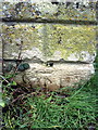
The Geograph project started in 2005 with the aim of publishing, organising and preserving representative images for every square kilometre of Great Britain, Ireland and the Isle of Man.

There are currently over 7.5m images from over14,400 individuals and you can help contribute to the project by visiting https://www.geograph.org.uk
Image Map (Loading...)


Getting Data...Please wait
Leaflet Map data © OpenStreetMap
Images are licensed for reuse under creativecommons.org/licenses/by-sa/2.0
Notes
- Clicking on the map will re-center to the selected point.
- The higher the marker number, the further away the image location is from the centre of the postcode.
Image Listing (276 Images Found)
Images are licensed for reuse under creativecommons.org/licenses/by-sa/2.0
Image
Details
Distance
1
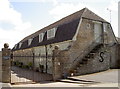
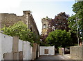
Greystone Mews
An intriguing group of residences - surely a conversion of a much older, rustic property.
Image: © Neil Owen
Taken: 10 Jun 2014
0.01 miles
2
Benchmark on Swindon Masonic Association Ltd's building, The Planks
Ordnance Survey cut mark benchmark described on the Bench Mark Database at http://www.bench-marks.org.uk/bm37346
Image: © Roger Templeman
Taken: 18 Mar 2011
0.02 miles
3
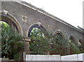
A row of empty arches
The former Corn Exchange also had a Butter Market in the triangular shaped building attached to it. In latter times it also offered a skating rink, cinema, bingo hall and ballroom. These many changes failed to stop the decline and eventual dereliction. However, plans have been accepted to completely reinvigorate this historic site. See Image] for more.
Image: © Neil Owen
Taken: 10 Jun 2014
0.04 miles
4
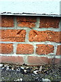
Benchmark on the end of wall pier, The Planks
Ordnance Survey inverted cut mark benchmark described on the Bench Mark Database at http://www.bench-marks.org.uk/bm37348
Image: © Roger Templeman
Taken: 18 Mar 2011
0.05 miles
5
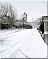
The Weavers in snow
This modern residential street is a turning off Old Mill Lane, and leads up to a lane called The Planks. In the distance is a building with a tower, which was formerly the Corn Exchange. Later it became The Locarno. Since this photograph was taken, the building was badly damaged by fire. There have been plans to restore it as part of a wider development but it was reported by the BBC and the local press, in March 2009, that companies linked with the plans were in administration. Hopefully someone will restore it, as Swindon has already lost a lot of interesting buildings in this area.
Image: © P L Chadwick
Taken: Unknown
0.05 miles
6
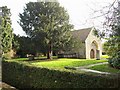
Holy Rood church, Swindon
All that remains of the original church is the chancel, now occasionally used as a chapel. Holy Rood, first recorded in 1154, served the small, pre-railway hilltop town of Swindon. By the 1840s it was clear Holy Rood was inadequate for the growing population, and Sir George Gilbert Scott's Christ Church was dedicated in 1851. In 1852 Holy Rood was demolished, apart from the chancel and a few pillars. Holy Rood is located on The Lawn, a public park once property of the landowning Goddard family. The Goddard tomb is between chapel and tree.
Image: © Chris Randall
Taken: 2 Jan 2007
0.05 miles
7
The tower from the Planks
The sad sight of the old Corn Exchange as seen from the Planks. The fires that badly damaged the roofs has left it open to the elements. See Image] for more of this historic building.
Image: © Neil Owen
Taken: 10 Jun 2014
0.05 miles
8
Squeeze through
An unusual form of stile by the new residential development Mill Court. Not well marked, it is a footpath.
Image: © Neil Owen
Taken: 4 Sep 2014
0.06 miles
9
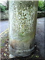
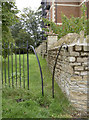
Benchmark on gatepost at entrance to The Lawn
Ordnance Survey cut mark benchmark described on the Bench Mark Database at http://www.bench-marks.org.uk/bm37345
Image: © Roger Templeman
Taken: 18 Mar 2011
0.06 miles
10
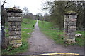
Gateposts at the entrance to The Lawn park
There is a benchmark Image at the base of the left hand side gatepost
Image: © Roger Templeman
Taken: 18 Mar 2011
0.06 miles