IMAGES TAKEN NEAR TO
Euclid Street, SWINDON, SN2 9SD
Introduction
This page details the photographs taken nearby to Euclid Street, SN2 9SD by members of the Geograph project.
The Geograph project started in 2005 with the aim of publishing, organising and preserving representative images for every square kilometre of Great Britain, Ireland and the Isle of Man.

There are currently over 7.5m images from over14,400 individuals and you can help contribute to the project by visiting https://www.geograph.org.uk
Image Map
Images are licensed for reuse under creativecommons.org/licenses/by-sa/2.0
Notes
- Clicking on the map will re-center to the selected point.
- The higher the marker number, the further away the image location is from the centre of the postcode.
Image Listing (338 Images Found)
Images are licensed for reuse under creativecommons.org/licenses/by-sa/2.0
Image
Details
Distance
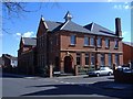
1
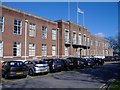
Civic Offices, Swindon
Swindon's current town hall, in Euclid street.
Image: © Roger Cornfoot
Taken: 13 Mar 2007
0.03 miles
2
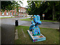
Swindog No. 6: Love Grows
Part of the Big Dog Art Trail around Swindon, this one is outside Swindon Council's offices.
Image: © Gareth James
Taken: 13 Aug 2023
0.04 miles
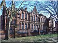
3
![Euclid Street School [1]](https://s0.geograph.org.uk/geophotos/05/33/67/5336776_e32344dd_120x120.jpg)
Euclid Street School [1]
This delightful brick building was built in 1897 as a pupil teacher training centre for Board schools. Now converted into apartments, it is listed, grade II, with details at: https://www.historicengland.org.uk/listing/the-list/list-entry/1389602
Image: © Michael Dibb
Taken: 28 Mar 2017
0.05 miles
4
![Euclid Street School [2]](https://s2.geograph.org.uk/geophotos/05/33/67/5336778_7adf4240_120x120.jpg)
Euclid Street School [2]
This delightful brick building was built in 1897 as a pupil teacher training centre for Board schools. Now converted into apartments, it is listed, grade II, with details at: https://www.historicengland.org.uk/listing/the-list/list-entry/1389602
Image: © Michael Dibb
Taken: 28 Mar 2017
0.05 miles
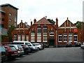
6
Former Clarence Street School, Infants School
Built 1903 as an addition to the main school https://www.geograph.org.uk/photo/7235684 , now offices of Swindon Borough Council. Listed Grade II.
Image: © Alan Murray-Rust
Taken: 15 Jul 2022
0.06 miles
7
Studio apartments, Lincoln Street, Swindon
Recently converted from educational use.
Image: © Roger Cornfoot
Taken: 13 Mar 2007
0.06 miles
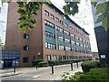
8
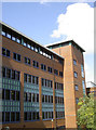
Princes Street block
Plenty of red brick and blue panelling. Swindon Borough Council's Wat Tyler House.
Image: © Neil Owen
Taken: 10 Jun 2014
0.07 miles
9
Former Clarence Street Infants' school, Swindon
The Victorian redbrick building is now used by Swindon Borough Council as part of its Social Services department, aptly enough, Children's Services. At left is the much more modern Wat Tyler House, also occupied by the Council and, as might be deduced by its name, put up in the late 1980s by the then Labour administration when everyone was up in arms about the ill-fated Conservative changes to local government finances, the poll tax.
Image: © Brian Robert Marshall
Taken: 16 Sep 2008
0.07 miles
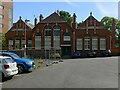
10
Clarence House, Swindon
This former school, is one of several buildings occupied as offices, by Swindon Borough Council.
Image: © Roger Cornfoot
Taken: 13 Mar 2007
0.07 miles