IMAGES TAKEN NEAR TO
Bevan Close, SWINDON, SN2 7LS
Introduction
This page details the photographs taken nearby to Bevan Close, SN2 7LS by members of the Geograph project.
The Geograph project started in 2005 with the aim of publishing, organising and preserving representative images for every square kilometre of Great Britain, Ireland and the Isle of Man.

There are currently over 7.5m images from over14,400 individuals and you can help contribute to the project by visiting https://www.geograph.org.uk
Image Map
Images are licensed for reuse under creativecommons.org/licenses/by-sa/2.0
Notes
- Clicking on the map will re-center to the selected point.
- The higher the marker number, the further away the image location is from the centre of the postcode.
Image Listing (10 Images Found)
Images are licensed for reuse under creativecommons.org/licenses/by-sa/2.0
Image
Details
Distance
1
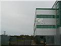
Direct UK Transport Ltd, Radway Road, Swindon
This is a fairly recent addition to the growing logistics industry in Swindon. The houses in the background are in Meadowcroft, Upper Stratton, Swindon, and would have been built in the 1950s. They are at SU166871.
Image: © Brian Robert Marshall
Taken: 1 Jan 2007
0.08 miles
2
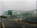
Direct UK Transport Ltd, Radway Road, Swindon
Another view of this logistics company, it shows evidence of someone at the planning stage taking account of the interests of the houses in Meadowcroft visible at the extreme left of the image. The noise-producing activities i.e. vehicle movements and loading/unloading operations are shielded from the houses by the layout and orientation of the warehouse itself. This is best seen on Google Earth.
Image: © Brian Robert Marshall
Taken: 1 Jan 2007
0.08 miles
3
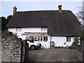
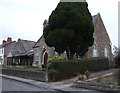
41 Green Road, Upper Stratton
No. 41 Green Road, Upper Stratton is a Grade II Listed thatched cottage. It was probably built in the early 18th century, long before Stratton St. Margaret was urbanised by expansion of Swindon with the coming of the railway. http://www.britishlistedbuildings.co.uk/en-318559-41-stratton-st-margaret
Image: © Vieve Forward
Taken: 14 Feb 2012
0.18 miles
4
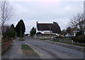
41 Green Road, Upper Stratton
No. 41 Green Road, Upper Stratton is a Grade II listed thatched cottage. It was probably built in the early 18th century, long before Stratton St. Margaret was urbanised by expansion of Swindon with the coming of the railway. http://www.britishlistedbuildings.co.uk/en-318559-41-stratton-st-margaret
Image: © Vieve Forward
Taken: 8 Feb 2012
0.19 miles
5
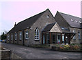
Former Sunday School, Upper Stratton Baptist Church, Green Road
This former Sunday School was built alongside Upper Stratton Baptist Church in 1929. http://usbc.org.uk/ http://www.flickr.com/photos/swindonlocal/3925580705/in/photostream/
Image: © Vieve Forward
Taken: 14 Feb 2012
0.20 miles
6
Upper Stratton Baptist Church, Green Road
Upper Stratton Baptist chapel was founded in 1861 and the Church formed in 1862. At first the building doubled as a school; the Sunday School (to the left of the picture) was added in 1929. http://usbc.org.uk/ http://www.flickr.com/photos/swindonlocal/3925580699/ http://www.flickr.com/photos/swindonlocal/3925580705/in/photostream/
Image: © Vieve Forward
Taken: 8 Feb 2012
0.21 miles
7
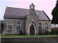
Upper Stratton Baptist Church, Green Road
Upper Stratton Baptist chapel was founded in 1861 and the Church formed in 1862. At first the building doubled as a school, as there was no school in the village at the time. In 1929 a Sunday School was built alongside the church. The church bell fell from use in 1886, and was later sent to Jamaica in response to an appeal from the Baptist Missionary Society. http://usbc.org.uk/ http://www.flickr.com/photos/swindonlocal/3925580699/ http://www.flickr.com/photos/swindonlocal/3925580705/in/photostream/
Image: © Vieve Forward
Taken: 14 Feb 2012
0.21 miles
8
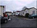
Abbeywood Park, off Green Road
Abbeywood Park residential static caravan site.
Image: © Vieve Forward
Taken: 8 Feb 2012
0.22 miles
9
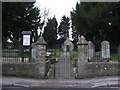
Green Road Cemetery
Green Road Cemetery is located opposite Upper Stratton Baptist Church in Green Road. It is owned by Stratton St. Margaret Parish Council and is for the interment of residents of the parish only.
http://www.strattonstmargaret.gov.uk/Services/Cemeteries.aspx
Image: © Vieve Forward
Taken: 8 Feb 2012
0.23 miles
10

Cemetery Chapel at Upper Stratton
Viewed from the north-east.
Image: © Peter Wood
Taken: 1 Oct 2015
0.24 miles