IMAGES TAKEN NEAR TO
SN2 6AW
Introduction
This page details the photographs taken nearby to SN2 6AW by members of the Geograph project.
The Geograph project started in 2005 with the aim of publishing, organising and preserving representative images for every square kilometre of Great Britain, Ireland and the Isle of Man.

There are currently over 7.5m images from over14,400 individuals and you can help contribute to the project by visiting https://www.geograph.org.uk
Image Map
Images are licensed for reuse under creativecommons.org/licenses/by-sa/2.0
Notes
- Clicking on the map will re-center to the selected point.
- The higher the marker number, the further away the image location is from the centre of the postcode.
Image Listing (41 Images Found)
Images are licensed for reuse under creativecommons.org/licenses/by-sa/2.0
Image
Details
Distance
1
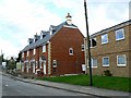
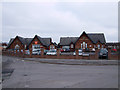
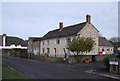
'Old Dairy Close', Green Road, Upper Stratton, Swindon
The title includes apostrophes as that is how the developer describes it. This was a demolition site less than five months ago Image
Image: © Brian Robert Marshall
Taken: 6 Apr 2008
0.02 miles
2
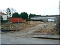
Site of 6 Green Road, Upper Stratton, Swindon
Also pictured in Image the site of an old dairy is well on the way to being cleared. The site is to be developed as flats and a house in 2008. Watch this space for progress on that project.
Image: © Brian Robert Marshall
Taken: 27 Nov 2007
0.02 miles
3
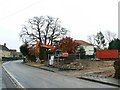
Site of 6 Green Road, Upper Stratton, Swindon
This location in January 2007 can be viewed here Image The appeal mentioned in the description to that image was successful and demolition has nearly been completed. Local news coverage: http://www.swindonadvertiser.co.uk/search/display.var.1858021.0.old_dairy_bites_the_dust.php
In case the link is deleted the text reads as follows:
"A PILE of rubble is all that now remains of a much-loved building that stood in Upper Stratton for more than 100 years.
Last week the diggers moved in to start knocking down the Old Dairy, in Green Road.
And it took just days for them to reduce the Victorian redbrick building to a pile of bricks.
Residents living nearby have protested against the demolition for years.
The application to develop the site was turned down a number of times, but permission was granted in September.
Karen Doyle, who started a petition to save the building in January, last month laid down in front of the diggers to try and stop them entering the site.
She said it was heartbreaking to see the building gone.
"We've had to watch that lovely, old building be pulled down," said the 46-year-old.
"My daughter even went out and stood in front of the diggers again last week.
"She said it was so sad that they were destroying this old building."
As part of the demolition work a tree on the site, which had been under a protection order, will be torn down.
Karen said inspectors told her it was split down the middle and was a danger.
"I'm not against progress in any way," said Karen.
"But they keep tearing down all of Swindon's heritage."
Coun David Sammels (Con, St Philips) said he was disappointed that the building had been razed to the ground.
"This is, to me, an absolute travesty," he said.
"The Old Dairy was a magnificent Victorian era building that should have been saved for future generations to enjoy.
"The building is unique and represents an important part of the history of the area."
He said that the Bristol Planning Inspectorate had overturned Swindon Council's refusal of the application.
"The process has been a little confusing and therefore I am setting up a meeting in the near future for local residents to understand what has happened with the application," he said.
Builders will now clear the site and start work on eight flats and one house.
Work is expected to begin next month." From Swindon Advertiser 26 November 2007.
Image: © Brian Robert Marshall
Taken: 27 Nov 2007
0.02 miles
4
Stratton Education Centre, Green Road, Upper Stratton
Stratton Education Centre Pupil Referral Unit is housed in this former school.
Image: © Vieve Forward
Taken: 8 Feb 2012
0.03 miles
5
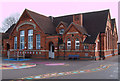
Beechcroft Infant School, Beechcroft Road, Upper Stratton
Built in 1892, Beechcroft Infant School, Upper Stratton is a former Board school.
Image: © Vieve Forward
Taken: 14 Feb 2012
0.03 miles
6
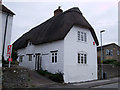
19 Green Road, Upper Stratton
No. 19 Green Road, Upper Stratton is a Grade II Listed thatched cottage. Probably built in the 17th century, it is a former dame school. Its principal architectural feature (not visible on this picture) is an external stepped wall chimney stack with attached bread oven. It was built long before Stratton St. Margaret became urbanised after the coming of the railway to Swindon.
http://www.britishlistedbuildings.co.uk/en-318557-19-stratton-st-margaret http://www.heritage-explorer.co.uk/web/he/searchdetail.aspx?id=5141&crit=
Image: © Vieve Forward
Taken: 8 Feb 2012
0.04 miles
7
19 Green Road, Upper Stratton
No. 19 Green Road, Upper Stratton is a Grade II Listed thatched cottage. Probably built in the 17th century, it is a former dame school. Its principal architectural feature is an external stepped wall chimney stack with attached bread oven. It was built long before Stratton St. Margaret became urbanised after the coming of the railway to Swindon.
http://www.britishlistedbuildings.co.uk/en-318557-19-stratton-st-margaret http://www.heritage-explorer.co.uk/web/he/searchdetail.aspx?id=5141&crit=
Image: © Vieve Forward
Taken: 14 Feb 2012
0.05 miles
8
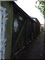
Railway carriage used as a shed, Dores Road, Upper Stratton
This old goods wagon has been converted to a shed, seen here from the back in an alley off Dores Road, Upper Stratton. It probably came from the (now disused) Great Western Railways Swindon-Highworth branch line, just over 0.5 km to the south.
Image: © Vieve Forward
Taken: 14 Feb 2012
0.05 miles
9
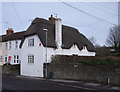
21 Green Road, Upper Stratton
This c. 18th century Grade II Listed stone building with stone tiled roof and modern extensions is the survivor of an ancient hamlet, and now houses the offices of the Swindon Youth Offending Team. http://www.britishlistedbuildings.co.uk/en-318558-21-stratton-st-margaret
Image: © Vieve Forward
Taken: 14 Feb 2012
0.05 miles
10
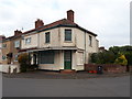
House, formerly Bendell's shop, Dores Road
See https://www.flickr.com/photos/swindonlocal/28794293721/in/photolist-TrCFkX-994GXV-82ho73-bcezeD-KSshm2-G8zPGb-QknnKZ-8axMPR-818Ch9-2ivuVzS-9t9goR-fpFDUK-aUNSnB-aUNSiM-2iwKKNx
Image: © Vieve Forward
Taken: 5 May 2020
0.06 miles