IMAGES TAKEN NEAR TO
Blunsdon, SWINDON, SN26 8DF
Introduction
This page details the photographs taken nearby to SN26 8DF by members of the Geograph project.
The Geograph project started in 2005 with the aim of publishing, organising and preserving representative images for every square kilometre of Great Britain, Ireland and the Isle of Man.

There are currently over 7.5m images from over14,400 individuals and you can help contribute to the project by visiting https://www.geograph.org.uk
Image Map
Images are licensed for reuse under creativecommons.org/licenses/by-sa/2.0
Notes
- Clicking on the map will re-center to the selected point.
- The higher the marker number, the further away the image location is from the centre of the postcode.
Image Listing (5 Images Found)
Images are licensed for reuse under creativecommons.org/licenses/by-sa/2.0
Image
Details
Distance
1
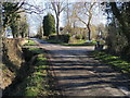
Back Lane
Back Lane passing Ivy Lane
Image: © Shaun Ferguson
Taken: 25 Feb 2012
0.18 miles
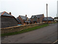
3
Back Lane, Broad Blunsdon
The back of the Lower Village, the other parallel road is Front Lane.
Image: © Robin Webster
Taken: 19 Jan 2020
0.22 miles
4
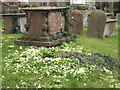
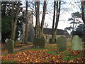
St. Leonard's, B.Blunsdon in Spring
The profusion of primroses in spring make this a very attractive churchyard.
Image: © roger ellis
Taken: 3 Apr 2007
0.23 miles