IMAGES TAKEN NEAR TO
Blunsdon, SWINDON, SN26 8DB
Introduction
This page details the photographs taken nearby to SN26 8DB by members of the Geograph project.
The Geograph project started in 2005 with the aim of publishing, organising and preserving representative images for every square kilometre of Great Britain, Ireland and the Isle of Man.

There are currently over 7.5m images from over14,400 individuals and you can help contribute to the project by visiting https://www.geograph.org.uk
Image Map
Images are licensed for reuse under creativecommons.org/licenses/by-sa/2.0
Notes
- Clicking on the map will re-center to the selected point.
- The higher the marker number, the further away the image location is from the centre of the postcode.
Image Listing (13 Images Found)
Images are licensed for reuse under creativecommons.org/licenses/by-sa/2.0
Image
Details
Distance
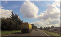
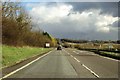
1
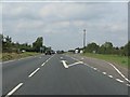
A419 back on Ermin Way
After the curves of Blunsdon's bypass, it's back to Roman straightness.
Image: © J Whatley
Taken: 22 Sep 2010
0.03 miles
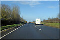
2
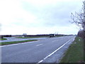
A419 Ermin Way
A Roman Road towards Cirencester.
Image: © Julian P Guffogg
Taken: 7 Aug 2013
0.04 miles
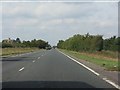
3
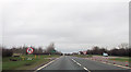
A419 at Lower Widhill Farm turning
The right hand turn only provides a "U"-turn and, thereby, access to Widhill House.
Image: © J Whatley
Taken: 22 Sep 2010
0.14 miles
4
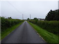
A419 at the entrance to Lower Widhill Farm
Image: © Jonathan Billinger
Taken: 28 Feb 2007
0.15 miles
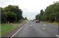
7
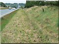
Grass verge, A419 north of Blunsdon, Swindon
The verge has recently been cut in the image facing south-east towards Blunsdon. The cars visible in the image approaching the viewpoint have just entered this square from the next square east.
Image: © Brian Robert Marshall
Taken: 2 Sep 2007
0.20 miles
8
The A419 to Swindon
The A419 follows the Roman Road, Ermin Street.
Image: © Steve Daniels
Taken: 23 Mar 2014
0.20 miles