IMAGES TAKEN NEAR TO
Coln Road, SN26 8AN
Introduction
This page details the photographs taken nearby to Coln Road, SN26 8AN by members of the Geograph project.
The Geograph project started in 2005 with the aim of publishing, organising and preserving representative images for every square kilometre of Great Britain, Ireland and the Isle of Man.

There are currently over 7.5m images from over14,400 individuals and you can help contribute to the project by visiting https://www.geograph.org.uk
Image Map
Images are licensed for reuse under creativecommons.org/licenses/by-sa/2.0
Notes
- Clicking on the map will re-center to the selected point.
- The higher the marker number, the further away the image location is from the centre of the postcode.
Image Listing (17 Images Found)
Images are licensed for reuse under creativecommons.org/licenses/by-sa/2.0
Image
Details
Distance
1
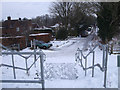
Widhill Lane, Broad Blunsdon
The view down Widhill Lane from Widhill Walk Bridge. The bridge takes a bridleway across the A419 dual carriageway. (Horses or bikes can descend beside the steps).
Image: © Vieve Forward
Taken: 22 Jan 2013
0.11 miles
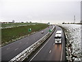
3
Blunsdon Hill, Blunsdon, Swindon
Not a view that could easily have been captured until a few weeks ago. This is the route of the old Roman road of Ermin Street. It has served as the highway between Cirencester and points south-east from the early years of the first millennium until November 2008 when it was by-passed. It remains to provide access to a refuse tip and a few properties.
Image: © Brian Robert Marshall
Taken: 25 Dec 2008
0.13 miles
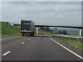
4
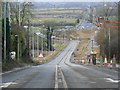
Blunsdon bypass
The A419, looking south / south-east.
Image: © Gareth James
Taken: 23 Dec 2009
0.18 miles
5
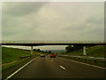
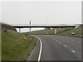
A419 - new footbridge on the Blunsdon bypass
Image: © J Whatley
Taken: 22 Sep 2010
0.19 miles
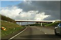
7
A419 new section
Footbridge ahead.
This new section of road deviates from the old Roman Road, Ermin Way.
Image: © Julian P Guffogg
Taken: 7 Aug 2013
0.19 miles
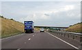
9
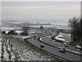
Blunsdon bypass
The A419, looking north / north-west from the footbridge at the end of Widhill Lane.
Image: © Gareth James
Taken: 23 Dec 2009
0.20 miles