IMAGES TAKEN NEAR TO
Holdcroft Close, SWINDON, SN26 7AL
Introduction
This page details the photographs taken nearby to Holdcroft Close, SN26 7AL by members of the Geograph project.
The Geograph project started in 2005 with the aim of publishing, organising and preserving representative images for every square kilometre of Great Britain, Ireland and the Isle of Man.

There are currently over 7.5m images from over14,400 individuals and you can help contribute to the project by visiting https://www.geograph.org.uk
Image Map
Images are licensed for reuse under creativecommons.org/licenses/by-sa/2.0
Notes
- Clicking on the map will re-center to the selected point.
- The higher the marker number, the further away the image location is from the centre of the postcode.
Image Listing (46 Images Found)
Images are licensed for reuse under creativecommons.org/licenses/by-sa/2.0
Image
Details
Distance
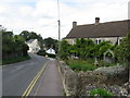
2
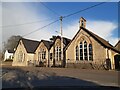
Blunsdon Village Hall
Former school in the village.
Image: © Gareth James
Taken: 1 Apr 2022
0.05 miles
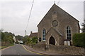
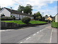
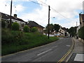
7
High Street, Blunsdon
At the junction with Churchway, Burytown Lane & Sams Lane near St. Leonard's Church
Image: © Geographer
Taken: 14 Jul 2022
0.11 miles
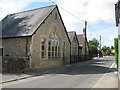
8
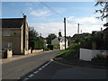
Looking down Blunsdon High Street
From the junction with Hatcher's Crescent (right).
Image: © Gareth James
Taken: 23 Aug 2009
0.12 miles
9
Blunsdon High Street
Note the Heart in Hand public house.
Image: © Gareth James
Taken: 23 Aug 2009
0.12 miles
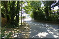
10
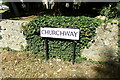
Churchway sign
On Churchway at the junction with Burytown Lane near St. Leonard' Church
Image: © Geographer
Taken: 14 Jul 2022
0.13 miles