IMAGES TAKEN NEAR TO
Penhill Drive, SWINDON, SN2 5HG
Introduction
This page details the photographs taken nearby to Penhill Drive, SN2 5HG by members of the Geograph project.
The Geograph project started in 2005 with the aim of publishing, organising and preserving representative images for every square kilometre of Great Britain, Ireland and the Isle of Man.

There are currently over 7.5m images from over14,400 individuals and you can help contribute to the project by visiting https://www.geograph.org.uk
Image Map
Images are licensed for reuse under creativecommons.org/licenses/by-sa/2.0
Notes
- Clicking on the map will re-center to the selected point.
- The higher the marker number, the further away the image location is from the centre of the postcode.
Image Listing (15 Images Found)
Images are licensed for reuse under creativecommons.org/licenses/by-sa/2.0
Image
Details
Distance
1
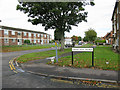
Junction of Grafton Road with Penhill Drive
Image: © Nick Smith
Taken: 26 Sep 2011
0.04 miles
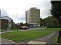
4
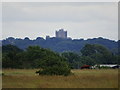
Cleverton Court, Penhill, Swindon
The title refers to the rather austere block of social housing on the skyline. It is about 8.5 kilometres from the viewpoint at RAF Blakehill nature reserve.
Image: © Brian Robert Marshall
Taken: 8 Jul 2020
0.07 miles
5
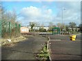
Don't park and don't ride
Disused Park and Ride facility on Cricklade Road
Image: © Antony Dixon
Taken: 5 Mar 2012
0.10 miles
6
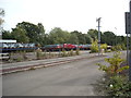
Electrification store, former Park-and-Ride, Cricklade Road
Former Park-and-Ride Image] being used to store equipment for railway electrification.
Image: © Vieve Forward
Taken: 13 Sep 2015
0.13 miles
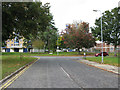
7
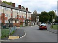
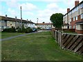
Westwood Road, Penhill, Swindon
The street-naming theme in Penhill is Wiltshire towns and villages. Westwood is a village near the county border with Bath and North-East Somerset. The three-storey block at the left contains quite roomy maisonettes. Penhill has benefited from a mid-life update carried out by the Council as can be seen from the external appearance of the block.
Image: © Brian Robert Marshall
Taken: 3 Oct 2008
0.13 miles
9
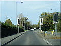
Staverton Way, Penhill, Swindon
Staverton Way leads north from Westwood Road. It contains a mix of terraced houses and maisonettes within a three-storey block, seen at the right. Penhill is typical of mid 20th century municipal housing estates to be found in many parts of the UK.
Image: © Brian Robert Marshall
Taken: 3 Oct 2008
0.16 miles
10
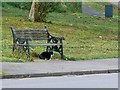
Bench and cat, Ramsbury Avenue, Penhill, Swindon
I love cats and appreciate the value of benches. The two together make a nice snap.
Image: © Brian Robert Marshall
Taken: 3 Oct 2008
0.23 miles