IMAGES TAKEN NEAR TO
Kingsdown Lane, SWINDON, SN25 5DN
Introduction
This page details the photographs taken nearby to Kingsdown Lane, SN25 5DN by members of the Geograph project.
The Geograph project started in 2005 with the aim of publishing, organising and preserving representative images for every square kilometre of Great Britain, Ireland and the Isle of Man.

There are currently over 7.5m images from over14,400 individuals and you can help contribute to the project by visiting https://www.geograph.org.uk
Image Map
Images are licensed for reuse under creativecommons.org/licenses/by-sa/2.0
Notes
- Clicking on the map will re-center to the selected point.
- The higher the marker number, the further away the image location is from the centre of the postcode.
Image Listing (5 Images Found)
Images are licensed for reuse under creativecommons.org/licenses/by-sa/2.0
Image
Details
Distance
1
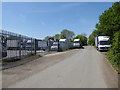
BB Commercial Trading Ltd., Kingsdown Lane
Entrance to a firm specialising in commercial vehicle parts and components.
Image: © Vieve Forward
Taken: 10 May 2017
0.04 miles
2

Kingsdown Nurseries Kingsdown Lane Blunsdon Swindon
Strictly trade only, this nursery is at the end of a narrow lane off the old Ermin Street that runs parallel to the A419 through Blunsdon.
Image: © Brian Robert Marshall
Taken: 4 Nov 2006
0.08 miles
3
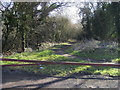
Kingsdown Lane (Track)
Kingsdown Lane (Track) heading to Highworth Road
Image: © Shaun Ferguson
Taken: 8 Mar 2012
0.11 miles
4
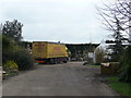
Sundries delivery at Kingsdown Nurseries
The business grows hardy plants for the commercial trade.
Image: © Jonathan Billinger
Taken: 26 Mar 2008
0.13 miles
5
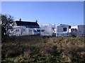
Hyde Farm, Turnpike Road, Blunsdon
The Forge, Hyde Farm is a certificated Motorhome caravan site.
Image: © Vieve Forward
Taken: 6 Mar 2012
0.16 miles