IMAGES TAKEN NEAR TO
Stephenson Road, SWINDON, SN25 5AX
Introduction
This page details the photographs taken nearby to Stephenson Road, SN25 5AX by members of the Geograph project.
The Geograph project started in 2005 with the aim of publishing, organising and preserving representative images for every square kilometre of Great Britain, Ireland and the Isle of Man.

There are currently over 7.5m images from over14,400 individuals and you can help contribute to the project by visiting https://www.geograph.org.uk
Image Map
Images are licensed for reuse under creativecommons.org/licenses/by-sa/2.0
Notes
- Clicking on the map will re-center to the selected point.
- The higher the marker number, the further away the image location is from the centre of the postcode.
Image Listing (15 Images Found)
Images are licensed for reuse under creativecommons.org/licenses/by-sa/2.0
Image
Details
Distance
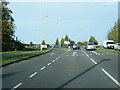
2
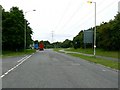
Arkwright Road,Groundwell Industrial Estate
This is the road into and out of the estate. In this view facing west Arkwright Road joins Cricklade Road, the main route from the north of Swindon to the strategic road network with connections to the M4 and M5.
Image: © Brian Robert Marshall
Taken: 16 Jul 2008
0.07 miles
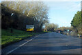
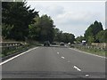
3

Refreshments at the lay-by on A311 Cricklade Road
Image: © Nick Smith
Taken: 26 Sep 2011
0.11 miles
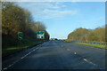
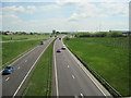
6
A419 north of Turnpike Junction
The bend takes the road across the line of Roman Ermin Street (later a turnpike road) and leads onto a recent bypass avoiding traffic lights near Abbey Stadium.
Image: © J Whatley
Taken: 22 Sep 2010
0.15 miles