IMAGES TAKEN NEAR TO
Gable Close, SWINDON, SN25 4XG
Introduction
This page details the photographs taken nearby to Gable Close, SN25 4XG by members of the Geograph project.
The Geograph project started in 2005 with the aim of publishing, organising and preserving representative images for every square kilometre of Great Britain, Ireland and the Isle of Man.

There are currently over 7.5m images from over14,400 individuals and you can help contribute to the project by visiting https://www.geograph.org.uk
Image Map
Images are licensed for reuse under creativecommons.org/licenses/by-sa/2.0
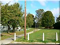
Notes
- Clicking on the map will re-center to the selected point.
- The higher the marker number, the further away the image location is from the centre of the postcode.
Image Listing (18 Images Found)
Images are licensed for reuse under creativecommons.org/licenses/by-sa/2.0
Image
Details
Distance
1
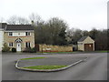
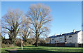
Gable Close
2000s houses in Abbey Mead.
Image: © Burgess Von Thunen
Taken: 29 Feb 2012
0.06 miles
2
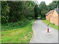
Foot and cycle path, near Glebe Close, Swindon
The path marks the southern edge of the northern development area of Swindon. This view is facing west.
Image: © Brian Robert Marshall
Taken: 3 Oct 2008
0.08 miles
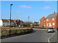
3
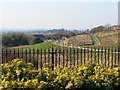
A view west from Thresher Drive, Groundwell, Swindon
The Groundwell residential area sits on rising land north of the established Penhill estate. In this west-facing view out of the square the cycle track enters the image at the right just about on the western gridline of this square.
Image: © Brian Robert Marshall
Taken: 16 Feb 2008
0.12 miles
4
Glebe Close, Swindon
This is the interface between the 1950s housing estate of Penhill, out of shot to the right, and the 1990s northern development area.
Image: © Brian Robert Marshall
Taken: 3 Oct 2008
0.12 miles
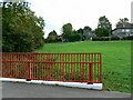
5
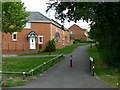
Path behind the Houses
One of a number of local paths and cycleways through grassy or wooded strips of land which have been left in between the housing.
Image: © Des Blenkinsopp
Taken: 19 Jan 2020
0.15 miles
6
Thresher Drive, Groundwell, Swindon
Thresher Drive is part of a fairly new residential development in the northern part of Swindon. In this view we are close to the north-western corner of the square. The houses are in the next square north. The small road the opening of which is just visible at the right is just within this square. The unusual tube structure in the centre of the image is part of Motorola who have a manufacturing facility here. The end of the tube is at SU149893.
Image: © Brian Robert Marshall
Taken: 16 Feb 2008
0.16 miles
7
Aldbourne Close, Penhill, Swindon
The bridge providing the viewpoint is at the northern limit of the 1950s estate but is rather newer. The houses providing the title are those to the right. Out of shot to the left is the southern edge of the northern development area.
Image: © Brian Robert Marshall
Taken: 3 Oct 2008
0.17 miles
8
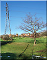
Pylon and Small Tree
Several strips of undeveloped land are to be found in this area. Possibly thought too steep to build on, they provide a bit of open space for local residents.
Image: © Des Blenkinsopp
Taken: 19 Jan 2020
0.17 miles
9
Melksham Close, Penhill, Swindon
This is the northern edge of the large municipal housing estate developed in the 1950s. It may not have existed had it not been for a land acquisition problem on the east side of Swindon where the next housing estate was planned, Walcot. This resulted in an 18 month hiatus and, rather than break up the housebuilding machine that had formed to build houses for the Council, the decision was made to extend Penhill further north than had originally been planned. This took up the slack until work started on Walcot in 1955. Rightly or wrongly 'the valley' as it became known gained a reputation as a sink for 'problem families'. An attempt to remove the stigma was made by the Council by trying to rename the area as 'Lower Penhill'. I don't think it caught on.
Image: © Brian Robert Marshall
Taken: 3 Oct 2008
0.18 miles
10
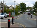
Ramsbury Avenue, Penhill, Swindon
The avenue is the spine road of 'the valley' area of Penhill, that part of the estate developed last. The entrance to Imber Walk is visible at the left behind the silver car. The pillar box is unlikely to be a Victorian post box or a Georgian post box or an Edwardian post box.
Image: © Brian Robert Marshall
Taken: 3 Oct 2008
0.20 miles