IMAGES TAKEN NEAR TO
Chatsworth Road, SWINDON, SN25 4UJ
Introduction
This page details the photographs taken nearby to Chatsworth Road, SN25 4UJ by members of the Geograph project.
The Geograph project started in 2005 with the aim of publishing, organising and preserving representative images for every square kilometre of Great Britain, Ireland and the Isle of Man.

There are currently over 7.5m images from over14,400 individuals and you can help contribute to the project by visiting https://www.geograph.org.uk
Image Map
Images are licensed for reuse under creativecommons.org/licenses/by-sa/2.0
Notes
- Clicking on the map will re-center to the selected point.
- The higher the marker number, the further away the image location is from the centre of the postcode.
Image Listing (18 Images Found)
Images are licensed for reuse under creativecommons.org/licenses/by-sa/2.0
Image
Details
Distance
1
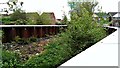
Haydon Wick Brook, Swindon (2)
One of a few photos showing a completed flood alleviation scheme in north Swindon. More below...
Image: © Brian Robert Marshall
Taken: 27 Apr 2014
0.07 miles
2
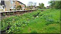
Haydon Wick Brook, Swindon (1)
One of a few photos showing a completed flood alleviation scheme in north Swindon. More below...
Image: © Brian Robert Marshall
Taken: 27 Apr 2014
0.11 miles
3
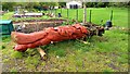
Golden Jubilee totem pole, Blunsdon Road, Haydon Wick, Swindon
The pole was once placed vertically somewhere to mark the 50th anniversary of the accession of Queen Elizabeth II. It rather looks as though the bottom section started to rot away and so it was laid to rest here for the time being. The representation of a cute furry animal appears to be that of a squirrel.
Image: © Brian Robert Marshall
Taken: 27 Apr 2014
0.11 miles
5
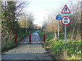
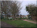
Haydon End Lane
The old lane to Haydon End Farm has now been pedestrianised to create a cycle and footpath past the housing estates and shopping malls of north Swindon.
Image: © Jonathan Billinger
Taken: 10 Dec 2009
0.17 miles
6
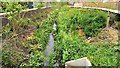
Haydon Wick Brook, Swindon (3)
One of a few photos showing a completed flood alleviation scheme in north Swindon. More below...
Image: © Brian Robert Marshall
Taken: 27 Apr 2014
0.17 miles
8
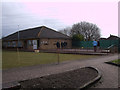
Haydon Wick Bowls Club
The Haydon Wick Bowls Club is situated behind the Haydon Centre, off Thames Avenue. It was established in the early 1990s.
http://haydonwickbc.co.uk/
Image: © Vieve Forward
Taken: 18 Feb 2012
0.19 miles
9
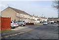
Furlong Close, Swindon
Viewed from the Thames Avenue end.
Image: © Jaggery
Taken: 12 Mar 2011
0.19 miles
10
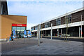
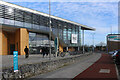
Road through the Orbital Park
This thoroughfare is between the two main buildings and is reserved for buses.
The small blue panels on the left tell the story of the aircraft industry which used to be here.
Image: © Des Blenkinsopp
Taken: 30 Jan 2023
0.19 miles