IMAGES TAKEN NEAR TO
Neighbourhood Centre, Highdown Way, SWINDON, SN25 4FD
Introduction
This page details the photographs taken nearby to Neighbourhood Centre, Highdown Way, SN25 4FD by members of the Geograph project.
The Geograph project started in 2005 with the aim of publishing, organising and preserving representative images for every square kilometre of Great Britain, Ireland and the Isle of Man.

There are currently over 7.5m images from over14,400 individuals and you can help contribute to the project by visiting https://www.geograph.org.uk
Image Map
Images are licensed for reuse under creativecommons.org/licenses/by-sa/2.0
Notes
- Clicking on the map will re-center to the selected point.
- The higher the marker number, the further away the image location is from the centre of the postcode.
Image Listing (12 Images Found)
Images are licensed for reuse under creativecommons.org/licenses/by-sa/2.0
Image
Details
Distance
1
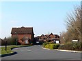
Thornhill Drive, St Andrew's Ridge, Swindon
This is a typical view within the Northern Expansion Area of Swindon, a development started in the 1990s to cater for housing demand from the local area and beyond. The development is continuing and will be for some time to come. Housing and estate design has improved in recent years, in my opinion at least.
Image: © Brian Robert Marshall
Taken: 16 Feb 2008
0.04 miles

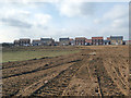
5
A view south-west from St Andrew's Ridge, Swindon
The area north of the established areas of Penhill and Haydon Wick and south of the village of Blunsdon is known generically as the Northern Expansion Area. It has been under development for several years from the early 1990s. Within the NEA are individual sub-areas with names such as St Andrew's Ridge, Redhouse and Priory Vale. I suspect they are mostly marketing-inspired though with a nod to existing names and features. Sadly, I can't remember many of them. In this view we can see the open space between St Andrew's Ridge behind the viewpoint and, I think, Redhouse, outside this square. The marker at the right indicates the presence of a bridleway.
Image: © Brian Robert Marshall
Taken: 16 Feb 2008
0.20 miles
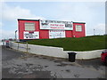
6
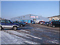
Blunsdon Market
Blunsdon Market is next to the greyhound and speedway stadium, and opens Wednesday, Saturday and Sunday mornings. It sells a large variety of goods at reasonable prices and has several cafes. A car boot sale usually takes place in the car park nearby on market days.
Image: © Vieve Forward
Taken: 11 Feb 2012
0.20 miles
7
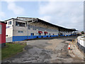
Abbey Stadium, Blunsdon St Andrew
Abbey Stadium hosts greyhound racing and motorcycle speedway (the local speedway team is Swindon Robins).
Image: © Vieve Forward
Taken: 3 Apr 2016
0.21 miles
9
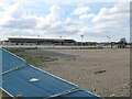
Gate A, Abbey Stadium, Blunsdon St Andrew
The main entrance to Abbey Stadium, which hosts greyhound racing and motorcycle speedway. Note the ornamental lamppost, one of several like it around the perimeter of the stadium.
Image: © Vieve Forward
Taken: 3 Apr 2016
0.23 miles
10
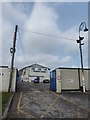
Hut, Abbey Stadium, Blunsdon St Andrew
This hut is just inside the entrance to the Abbey Stadium, which hosts greyhound racing and motorcycle speedway.
Image: © Vieve Forward
Taken: 3 Apr 2016
0.23 miles