IMAGES TAKEN NEAR TO
Clover Park, SWINDON, SN25 3JJ
Introduction
This page details the photographs taken nearby to Clover Park, SN25 3JJ by members of the Geograph project.
The Geograph project started in 2005 with the aim of publishing, organising and preserving representative images for every square kilometre of Great Britain, Ireland and the Isle of Man.

There are currently over 7.5m images from over14,400 individuals and you can help contribute to the project by visiting https://www.geograph.org.uk
Image Map
Images are licensed for reuse under creativecommons.org/licenses/by-sa/2.0
Notes
- Clicking on the map will re-center to the selected point.
- The higher the marker number, the further away the image location is from the centre of the postcode.
Image Listing (18 Images Found)
Images are licensed for reuse under creativecommons.org/licenses/by-sa/2.0
Image
Details
Distance
1
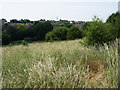
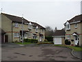
Green space, Ventnor Close, Moredon, Swindon
The green area is south of Ventor Close, part of the municipal housing estate developed in the 1950s. As far as I know is isn't a designated wildlife area. The houses in the distance are in Woodhall Park, a private housing estate built in the 1970s.
Image: © Brian Robert Marshall
Taken: 2 Jul 2009
0.02 miles
2
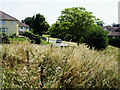
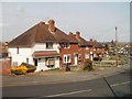
Shanklin Road, Moredon, Swindon
The houses on the left are in Shanklin Road, part of a 1950s municipal housing estate. Those on the right are in Locksgreen Crescent.
Image: © Brian Robert Marshall
Taken: 2 Jul 2009
0.04 miles
3
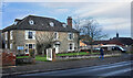
Park Farm, The Street
One of several older buildings along here which pre-date the 20th century suburban expansion which now covers most of this area.
Image: © Des Blenkinsopp
Taken: 30 Jan 2023
0.11 miles
4
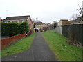
Haydon Wick
Path between Comfrey Close and Hylder Close.
Image: © Burgess Von Thunen
Taken: 29 Feb 2012
0.16 miles
5
Comfrey Close
1990s houses in Haydon Wick.
Image: © Burgess Von Thunen
Taken: 29 Feb 2012
0.16 miles
6
The Brow, Haydon Wick, Swindon
Houses on the west side of The Brow, a gently rising road between The Street and High Street, Haydon Wick.
Image: © Jaggery
Taken: 12 Mar 2011
0.17 miles
7
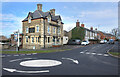
The Boundary House, Moredon
Serving beers from Arkell's, Swindon's independent brewer.
Image: © Roger Cornfoot
Taken: 10 Jan 2007
0.19 miles
8
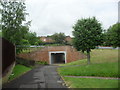
Haydon Wick
Underpass under Haydonleigh Drive.
Image: © Burgess Von Thunen
Taken: 6 Jun 2012
0.20 miles
9
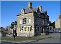
The Boundary House
At the junction of Moredon Road (foreground) and The Street.
The map shows there is a parish boundary down The Street and then off to the left, so the pub is right in the corner of the parish. Not sure which one.
Image: © Des Blenkinsopp
Taken: 30 Jan 2023
0.21 miles
10
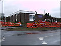
Moredon Community Centre, The Street, Moredon
Moredon Community Centre and Social Club has rooms to hire for social events.
Image: © Vieve Forward
Taken: 18 Feb 2012
0.21 miles