IMAGES TAKEN NEAR TO
Olive Grove, SWINDON, SN25 3DB
Introduction
This page details the photographs taken nearby to Olive Grove, SN25 3DB by members of the Geograph project.
The Geograph project started in 2005 with the aim of publishing, organising and preserving representative images for every square kilometre of Great Britain, Ireland and the Isle of Man.

There are currently over 7.5m images from over14,400 individuals and you can help contribute to the project by visiting https://www.geograph.org.uk
Image Map
Images are licensed for reuse under creativecommons.org/licenses/by-sa/2.0
Notes
- Clicking on the map will re-center to the selected point.
- The higher the marker number, the further away the image location is from the centre of the postcode.
Image Listing (25 Images Found)
Images are licensed for reuse under creativecommons.org/licenses/by-sa/2.0
Image
Details
Distance
1
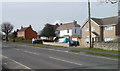
Whitworth Road houses, Swindon
Houses on the north side of the road, a few tens of metres west of Blackthorn Lane.
Image: © Jaggery
Taken: 12 Mar 2011
0.05 miles
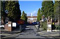
3
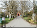
Whitworth Cemetery entrance drive, Swindon
Looking from the Whitworth Road entrance gates http://www.geograph.org.uk/photo/2304896 towards the cemetery chapel. http://www.geograph.org.uk/photo/2304901
Image: © Jaggery
Taken: 12 Mar 2011
0.11 miles
4
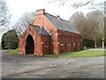
Whitworth Cemetery Chapel, Swindon
Located near the southern (Whitworth Road) entrance http://www.geograph.org.uk/photo/2304896 to the cemetery. Funeral services are held in this red-brick chapel, which has seating for about 60 people. A loop system is available for use by the hard of hearing.
Image: © Jaggery
Taken: 12 Mar 2011
0.11 miles
5

Swindon Academy, Beech Avenue, Pinehurst
Officially opened on July 2nd, 2010, this £30 million, state-of-the-art school boasts dance and drama studios, a floodlit all-weather pitch, an international standard sports hall, and nine science labs, and has a capacity of 1800. It replaces Pinehurst Infants and Junior Schools and Headlands School, and caters for pupils of all ages up to 18 years. It was built on the site of the Pinehurst People's Centre, which was demolished in 2007.
Image: © Vieve Forward
Taken: 20 Jan 2012
0.12 miles
6
Pinehurst People's Centre
A community centre, housed in part of a former school.
Image: © Roger Cornfoot
Taken: 10 Jan 2007
0.13 miles
7
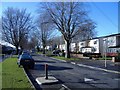
Beech Avenue
A broad, tree-lined street lined by refurbished, pre-fabricated houses.
Image: © Roger Cornfoot
Taken: 10 Jan 2007
0.14 miles
8
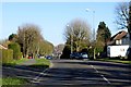
Whitworth Road (B4006)
Showing position of Postbox No. SN25 348.
See Image] for postbox.
Image: © JThomas
Taken: 15 Jul 2019
0.14 miles
9
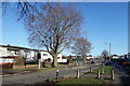
Beech Avenue, Swindon, again
Another picture along here. Not so many trees on this bit.
Image: © Des Blenkinsopp
Taken: 19 Jan 2020
0.15 miles
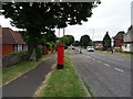
10
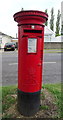
Elizabeth II postbox on Whitworth Road
Postbox No. SN25 348.
See Image] for context.
Image: © JThomas
Taken: 15 Jul 2019
0.15 miles