IMAGES TAKEN NEAR TO
Mendip Close, SWINDON, SN25 3BE
Introduction
This page details the photographs taken nearby to Mendip Close, SN25 3BE by members of the Geograph project.
The Geograph project started in 2005 with the aim of publishing, organising and preserving representative images for every square kilometre of Great Britain, Ireland and the Isle of Man.

There are currently over 7.5m images from over14,400 individuals and you can help contribute to the project by visiting https://www.geograph.org.uk
Image Map
Images are licensed for reuse under creativecommons.org/licenses/by-sa/2.0
Notes
- Clicking on the map will re-center to the selected point.
- The higher the marker number, the further away the image location is from the centre of the postcode.
Image Listing (59 Images Found)
Images are licensed for reuse under creativecommons.org/licenses/by-sa/2.0
Image
Details
Distance
1
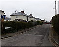
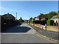
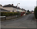
Hazel Grove, Pinehurst, Swindon
Viewed from The Circle looking along Hazel Grove towards Whitworth Road.
This is a through route for walkers and cyclists but not for motor vehicles
because concrete posts block the far end of the road.
Image: © Jaggery
Taken: 1 Dec 2014
0.07 miles
2
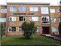
Claremont Court, Whitworth Road
In the window is a notice thanking all at the Great Western Hospital for their service during the 2020 COVID-19 pandemic. Rainbows were displayed in many windows during the pandemic, many of them drawn by children, to thank NHS staff and other key workers for their service.
Image: © Vieve Forward
Taken: 23 Apr 2020
0.10 miles
3
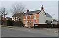
Swindon : corner of Whitworth Road and Mendip Close
Viewed across Whitworth Road (B4006).
Image: © Jaggery
Taken: 12 Mar 2011
0.11 miles
4
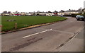
North side of The Circle, Pinehurst, Swindon
The Circle is a 200 metre diameter area of houses in the Pinehurst district of Swindon.
Image: © Jaggery
Taken: 1 Dec 2014
0.12 miles
6
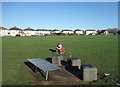
The Circle, Pinehurst
Part of a large round open space at the centre of the Pinehurst neighbourhood. I think the creature is a sort of bin.
Image: © Des Blenkinsopp
Taken: 19 Jan 2020
0.13 miles
7
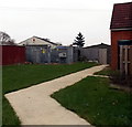
The Circle electricity substation, Pinehurst, Swindon
The SSE Power Distribution electricity substation is opposite this http://www.geograph.org.uk/photo/4400264 derelict former library.
Image: © Jaggery
Taken: 1 Dec 2014
0.13 miles
8
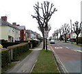
Pollarded trees, Pinehurst Road, Swindon
Pollarded trees give a somewhat eerie appearance to this suburban road.
Viewed from the corner of Whitworth Road.
Image: © Jaggery
Taken: 12 Mar 2011
0.14 miles
9
Laburnum Road, Pinehurst, Swindon
Looking towards Linden Avenue from The Circle.
Image: © Jaggery
Taken: 1 Dec 2014
0.14 miles
10
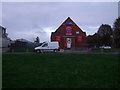
One Stop shop, The Circle, Pinehurst
The One Stop shop has been relocated from the western side of The Circle while the row of shops there Image] was demolished and is being redeveloped Image It has taken the place of the former Library building Image], which was housed in this former non-conformist chapel.
Image: © Vieve Forward
Taken: 24 Nov 2013
0.14 miles