IMAGES TAKEN NEAR TO
Selwyn Road, SWINDON, SN25 2RW
Introduction
This page details the photographs taken nearby to Selwyn Road, SN25 2RW by members of the Geograph project.
The Geograph project started in 2005 with the aim of publishing, organising and preserving representative images for every square kilometre of Great Britain, Ireland and the Isle of Man.

There are currently over 7.5m images from over14,400 individuals and you can help contribute to the project by visiting https://www.geograph.org.uk
Image Map
Images are licensed for reuse under creativecommons.org/licenses/by-sa/2.0
Notes
- Clicking on the map will re-center to the selected point.
- The higher the marker number, the further away the image location is from the centre of the postcode.
Image Listing (4 Images Found)
Images are licensed for reuse under creativecommons.org/licenses/by-sa/2.0
Image
Details
Distance
1
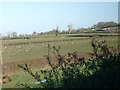
Grove Farm, north of Swindon.
How long before it gets swallowed up in the urban sprawl? To the south of the road where the picture was taken from is a new housing development on the outskirts of Swindon.
Image: © Martyn Pattison
Taken: 19 Dec 2004
0.16 miles
2
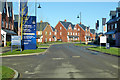
William Morris Way, Tadpole Garden Village
A new development pushing the Swindon suburbs further north.
Image: © Robin Webster
Taken: 19 Jan 2020
0.18 miles
3
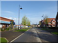
William Morris Street, Tadpole Garden Village
Two years on from my last photograph Image], the village is established and settled.
Image: © Vieve Forward
Taken: 22 Apr 2018
0.20 miles
4
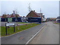
Burne Jones Avenue, Tadpole Garden Village
Houses being built in the new development on Tadpole Farm. The streets are all named after Pre-Raphaelites.
Image: © Vieve Forward
Taken: 16 Jul 2016
0.21 miles