IMAGES TAKEN NEAR TO
Addinsell Road, SWINDON, SN25 2NR
Introduction
This page details the photographs taken nearby to Addinsell Road, SN25 2NR by members of the Geograph project.
The Geograph project started in 2005 with the aim of publishing, organising and preserving representative images for every square kilometre of Great Britain, Ireland and the Isle of Man.

There are currently over 7.5m images from over14,400 individuals and you can help contribute to the project by visiting https://www.geograph.org.uk
Image Map
Images are licensed for reuse under creativecommons.org/licenses/by-sa/2.0
Notes
- Clicking on the map will re-center to the selected point.
- The higher the marker number, the further away the image location is from the centre of the postcode.
Image Listing (12 Images Found)
Images are licensed for reuse under creativecommons.org/licenses/by-sa/2.0
Image
Details
Distance
1
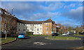
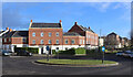
Addinsell Road
Curved terraces or crescents are just one of the many different types of housing that have been built in this neighbourhood.
Image: © Des Blenkinsopp
Taken: 30 Jan 2023
0.05 miles
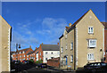
3
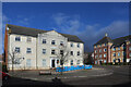
Large house on the corner
One of the many imposing new buildings in this recent part of town. It is unfortunate that the central section is discolouring rather badly.
Image: © Des Blenkinsopp
Taken: 30 Jan 2023
0.10 miles
4
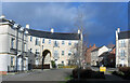
Archway in Britten Road
In a whole district where architects have been encouraged to go way beyond the normal "suburban housing" constraints, the two giant archways in Britten Road have to be some of the most flamboyant examples.
There is a matching one of these opposite, with a small green in the centre.
No endless roads of drab little boxes round here.
Image: © Des Blenkinsopp
Taken: 30 Jan 2023
0.12 miles
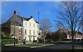
7
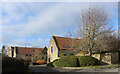
St Andrew's Court
With so many new places nearby built to look like something from times past, you could be forgiven for thinking that this was maybe another example.
But I think this is genuinely quite old. Converted farm buildings at a guess.
Image: © Des Blenkinsopp
Taken: 30 Jan 2023
0.23 miles
8
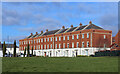
Terrace by a Green
Yet another variation in housing design in an area where architects seem to have been given a bit of a free hand.
Image: © Des Blenkinsopp
Taken: 30 Jan 2023
0.23 miles
9
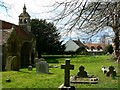
St Andrew's churchyard, Blunsdon St Andrew
This is a west-facing view past the main entrance porch of the church. The small housing development in the background is Lyall Close. More information on the church can be found in the description of this image Image
Image: © Brian Robert Marshall
Taken: 23 Mar 2008
0.23 miles
10
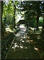
St Andrew's churchyard, Blunsdon St Andrew (a)
Image: © Basher Eyre
Taken: 4 Sep 2023
0.24 miles