IMAGES TAKEN NEAR TO
Redhouse Gardens, SWINDON, SN25 2GG
Introduction
This page details the photographs taken nearby to Redhouse Gardens, SN25 2GG by members of the Geograph project.
The Geograph project started in 2005 with the aim of publishing, organising and preserving representative images for every square kilometre of Great Britain, Ireland and the Isle of Man.

There are currently over 7.5m images from over14,400 individuals and you can help contribute to the project by visiting https://www.geograph.org.uk
Image Map
Images are licensed for reuse under creativecommons.org/licenses/by-sa/2.0
Notes
- Clicking on the map will re-center to the selected point.
- The higher the marker number, the further away the image location is from the centre of the postcode.
Image Listing (16 Images Found)
Images are licensed for reuse under creativecommons.org/licenses/by-sa/2.0
Image
Details
Distance
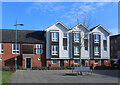
1
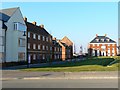
Priory Vale, Swindon
Housing design has moved on somewhat from previous decades and planners and developers do try to make new estates rather more visually interesting than hitherto.
Image: © Brian Robert Marshall
Taken: 16 Feb 2008
0.02 miles
2
Priory Vale, Swindon
Priory Vale is a part of the large Northern Expansion Area between the established areas of Haydon Wick to the south and Blunsdon to the north. It is still being developed as can be seen here.
Image: © Brian Robert Marshall
Taken: 16 Feb 2008
0.03 miles
4
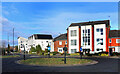
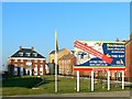
Roundabout, Redhouse Way
More of the mixed bag architecture that is found all over this recently built area.
Image: © Des Blenkinsopp
Taken: 30 Jan 2023
0.10 miles
5
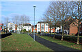
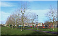
Part of Brook Park
Provision of open space must have been part of the brief for development of these areas.
Parks and greens and places to sit seem plentiful.
Image: © Des Blenkinsopp
Taken: 30 Jan 2023
0.10 miles
6
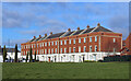
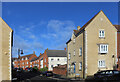
Terrace by a Green
Yet another variation in housing design in an area where architects seem to have been given a bit of a free hand.
Image: © Des Blenkinsopp
Taken: 30 Jan 2023
0.10 miles
7
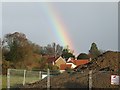
Rainbow over new houses
A view from the roundabout at the (current) end of one of the recently constructed roads on the massive development around Haydon Wick in Swindon. Dozens of different developers are building hundreds of new homes here.
Image: © Rob Farrow
Taken: 23 Nov 2006
0.11 miles
8
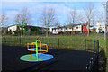
Play Area and Abbey Park School
The map names four other schools as well as Abbey Park all sharing the same large site in the central part of SU1289.
Image: © Des Blenkinsopp
Taken: 30 Jan 2023
0.11 miles