IMAGES TAKEN NEAR TO
Eastbury Way, SWINDON, SN25 2GB
Introduction
This page details the photographs taken nearby to Eastbury Way, SN25 2GB by members of the Geograph project.
The Geograph project started in 2005 with the aim of publishing, organising and preserving representative images for every square kilometre of Great Britain, Ireland and the Isle of Man.

There are currently over 7.5m images from over14,400 individuals and you can help contribute to the project by visiting https://www.geograph.org.uk
Image Map
Images are licensed for reuse under creativecommons.org/licenses/by-sa/2.0
Notes
- Clicking on the map will re-center to the selected point.
- The higher the marker number, the further away the image location is from the centre of the postcode.
Image Listing (14 Images Found)
Images are licensed for reuse under creativecommons.org/licenses/by-sa/2.0
Image
Details
Distance
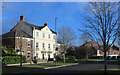
3
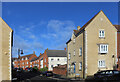
Addinsell Road
Curved terraces or crescents are just one of the many different types of housing that have been built in this neighbourhood.
Image: © Des Blenkinsopp
Taken: 30 Jan 2023
0.06 miles
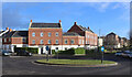
4
Archway in Britten Road
In a whole district where architects have been encouraged to go way beyond the normal "suburban housing" constraints, the two giant archways in Britten Road have to be some of the most flamboyant examples.
There is a matching one of these opposite, with a small green in the centre.
No endless roads of drab little boxes round here.
Image: © Des Blenkinsopp
Taken: 30 Jan 2023
0.07 miles
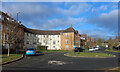
5
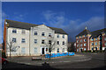
Large house on the corner
One of the many imposing new buildings in this recent part of town. It is unfortunate that the central section is discolouring rather badly.
Image: © Des Blenkinsopp
Taken: 30 Jan 2023
0.08 miles
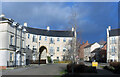
7
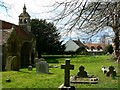
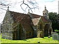
St Andrew's churchyard, Blunsdon St Andrew
This is a west-facing view past the main entrance porch of the church. The small housing development in the background is Lyall Close. More information on the church can be found in the description of this image Image
Image: © Brian Robert Marshall
Taken: 23 Mar 2008
0.23 miles
8
St Andrew's churchyard, Blunsdon St Andrew (a)
Image: © Basher Eyre
Taken: 4 Sep 2023
0.24 miles
9
St Andrew's church, Blunsdon St Andrew
The church is unusual in having a north-facing entrance. Typically churches have their main doors in the southern aspect. The church itself is Grade II* listed. The following information is extracted from the local authority website (Swindon.gov.uk)
"Church of St Andrew DCMS Ref: 7/90
Tadpole Lane Grade: II*
Blunsdon St Andrew First Listed: 26.01.55
Medieval traces. Practically rebuilt by Butterfield 1868. Small country church of rubble with red tile roof. C15 style grafted on early English. Chancel, nave and south aisle, west bell turret with 2 bells and odd spirelet. Three bay nave with central gabled porch to north with quatrefoil vent and trefoil heads to side buttresses. Hollow chamfered surround to pointed doorway (possibly C13), wrought iron strap hinges. A2 and a 3-light square headed Perpendicular style window with mouchette heads. Plain ashlar dressed paired lights to lower later 2 bay chancel with gabled organ vestry to north. Three light geometrical east window (with, inside, a foiled 'rere-arch' - in fact foiled reveal). The west front appears to be a different build: rough-faced rubble with ashlar bands. Central belfry break with 2 foiled openings and crenellated parapet to hipped roof; small octagonal spirelet and weathervane; this break is linked by wall thickening and buttress to small door to south-west with Caernarvon arch.
Foiled vesca-shape opening to right. Boiler house and chimney to south-west.
Interior: reused plain circa 1200 doorway (now a niche). Low 3 bay arcade, C13. Butterfield reredos, altar-rails, sedilia and pews retained. Nave roof: king post type with foiled braces. Rubble churchyard wall to south and to west, gabled doorway formerly entrance from Abbey. Numerous medieval fragments - sculpted stones, medieval tiles and some traces of an arcade found during work of 1868, indicating a later church in the Middle Ages."
Image: © Brian Robert Marshall
Taken: 23 Mar 2008
0.24 miles
10
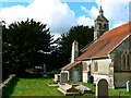
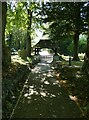
St Andrew's churchyard, Blunsdon St Andrew
The small south churchyard is viewed facing west. The main entrance is, somewhat unusually, on the north elevation. The small door in the image probably provides access to the boilerhouse. More information on the church can be found here Image
Image: © Brian Robert Marshall
Taken: 23 Mar 2008
0.24 miles