IMAGES TAKEN NEAR TO
Claydon Road, SWINDON, SN25 2ED
Introduction
This page details the photographs taken nearby to Claydon Road, SN25 2ED by members of the Geograph project.
The Geograph project started in 2005 with the aim of publishing, organising and preserving representative images for every square kilometre of Great Britain, Ireland and the Isle of Man.

There are currently over 7.5m images from over14,400 individuals and you can help contribute to the project by visiting https://www.geograph.org.uk
Image Map
Images are licensed for reuse under creativecommons.org/licenses/by-sa/2.0
Notes
- Clicking on the map will re-center to the selected point.
- The higher the marker number, the further away the image location is from the centre of the postcode.
Image Listing (12 Images Found)
Images are licensed for reuse under creativecommons.org/licenses/by-sa/2.0
Image
Details
Distance
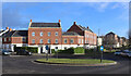
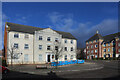
2
Archway in Britten Road
In a whole district where architects have been encouraged to go way beyond the normal "suburban housing" constraints, the two giant archways in Britten Road have to be some of the most flamboyant examples.
There is a matching one of these opposite, with a small green in the centre.
No endless roads of drab little boxes round here.
Image: © Des Blenkinsopp
Taken: 30 Jan 2023
0.13 miles
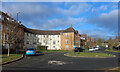
4
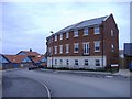
Conflicting styles at Blunsdon St Andrew
Typical of the mis-matches produced in the rapid expansion of Swindon in recent times. A 'city-style' apartment block overlooks a 'lego-style' primary school.
Image: © Roger Cornfoot
Taken: 15 Jan 2007
0.20 miles
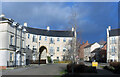
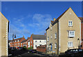
5
Large house on the corner
One of the many imposing new buildings in this recent part of town. It is unfortunate that the central section is discolouring rather badly.
Image: © Des Blenkinsopp
Taken: 30 Jan 2023
0.20 miles
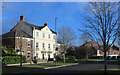
6
Addinsell Road
Curved terraces or crescents are just one of the many different types of housing that have been built in this neighbourhood.
Image: © Des Blenkinsopp
Taken: 30 Jan 2023
0.21 miles
7

View in the car park, Orbital Retail Park, Swindon
The McDonald's drive-thru is quite new and isn't yet on Google Earth, which was last updated in March 2007 at this location. This being 25 December, the retail park is deserted and the McDonald's closed.
Image: © Brian Robert Marshall
Taken: 25 Dec 2009
0.21 miles
9

McDonald's Drive-Thru, Orbital Retail Park, Swindon
This example of the popular and much-loved fast food outlets is fairly new having been built since March 2007, the last time one of the Google Earth planes flew over. It is on the north-western corner of the large retail park, conveniently located for shoppers who have maxed out their credit cards at the nearby Asda Walmart, Next or Marks and Spencer's.
Image: © Brian Robert Marshall
Taken: 25 Dec 2009
0.22 miles
10
![North Swindon District Centre [3]](https://s1.geograph.org.uk/geophotos/06/10/92/6109297_f145c7b3_120x120.jpg)
North Swindon District Centre [3]
Better known as the Orbital Shopping Park, all the usual suspects are here. The park has 16 units totalling 212,000 square feet, 990 car parks and claims a footfall of 5 million per annum.
Image: © Michael Dibb
Taken: 3 Apr 2019
0.24 miles