IMAGES TAKEN NEAR TO
Croome Close, SWINDON, SN25 2AF
Introduction
This page details the photographs taken nearby to Croome Close, SN25 2AF by members of the Geograph project.
The Geograph project started in 2005 with the aim of publishing, organising and preserving representative images for every square kilometre of Great Britain, Ireland and the Isle of Man.

There are currently over 7.5m images from over14,400 individuals and you can help contribute to the project by visiting https://www.geograph.org.uk
Image Map
Images are licensed for reuse under creativecommons.org/licenses/by-sa/2.0
Notes
- Clicking on the map will re-center to the selected point.
- The higher the marker number, the further away the image location is from the centre of the postcode.
Image Listing (6 Images Found)
Images are licensed for reuse under creativecommons.org/licenses/by-sa/2.0
Image
Details
Distance
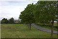
1
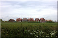
Oakhurst Way
A relatively older part of developments pushing the Swindon suburbs further north.
Image: © Robin Webster
Taken: 19 Jan 2020
0.04 miles
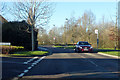
4
New housing development from Tadpole Lane
Image: © Robert Eva
Taken: 13 May 2017
0.19 miles
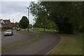
5
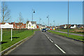
Greene Street, Tadpole Garden Village
One of the main approaches to this new development pushing the Swindon suburbs further north.
Image: © Robin Webster
Taken: 19 Jan 2020
0.19 miles