IMAGES TAKEN NEAR TO
Queen Elizabeth Drive, SWINDON, SN25 1WR
Introduction
This page details the photographs taken nearby to Queen Elizabeth Drive, SN25 1WR by members of the Geograph project.
The Geograph project started in 2005 with the aim of publishing, organising and preserving representative images for every square kilometre of Great Britain, Ireland and the Isle of Man.

There are currently over 7.5m images from over14,400 individuals and you can help contribute to the project by visiting https://www.geograph.org.uk
Image Map
Images are licensed for reuse under creativecommons.org/licenses/by-sa/2.0
Notes
- Clicking on the map will re-center to the selected point.
- The higher the marker number, the further away the image location is from the centre of the postcode.
Image Listing (4 Images Found)
Images are licensed for reuse under creativecommons.org/licenses/by-sa/2.0
Image
Details
Distance
1
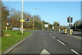
Traffic lights on A4198 Thamesdown Drive
Image: © Robin Webster
Taken: 19 Jan 2020
0.14 miles
2
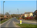
Garsington Drive, near Blunsdon St Andrew, Swindon
Garsington Drive is seen in this north-east facing view on its way out of the square. The house on the right is just inside the square.
Image: © Brian Robert Marshall
Taken: 16 Feb 2008
0.24 miles
3
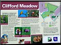
Clifford Meadow signage, off Thamesdown Drive, Swindon
Additional information.
Image: © Brian Robert Marshall
Taken: 28 Jan 2007
0.24 miles
4
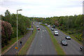
Thamesdown Drive looking west from the footbridge
Image: © Robert Eva
Taken: 13 May 2017
0.25 miles