IMAGES TAKEN NEAR TO
Rysy Court, SWINDON, SN25 1TH
Introduction
This page details the photographs taken nearby to Rysy Court, SN25 1TH by members of the Geograph project.
The Geograph project started in 2005 with the aim of publishing, organising and preserving representative images for every square kilometre of Great Britain, Ireland and the Isle of Man.

There are currently over 7.5m images from over14,400 individuals and you can help contribute to the project by visiting https://www.geograph.org.uk
Image Map
Images are licensed for reuse under creativecommons.org/licenses/by-sa/2.0
Notes
- Clicking on the map will re-center to the selected point.
- The higher the marker number, the further away the image location is from the centre of the postcode.
Image Listing (21 Images Found)
Images are licensed for reuse under creativecommons.org/licenses/by-sa/2.0
Image
Details
Distance
1
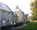
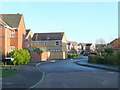
New houses in Swindon
Newly built traditional-style stone houses in Swindon. This development is by the builder Matthew Homes Limited. The balloons are there because the photograph was taken on the day of the Show House Opening.
Image: © Rob Farrow
Taken: 23 Nov 2006
0.06 miles
3
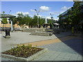
Concrete seating in the Orbital Retail Centre
Image: © Steve Daniels
Taken: 6 Jul 2009
0.14 miles
4
The Library in the Orbital Retail Park
Image: © Steve Daniels
Taken: 6 Jul 2009
0.15 miles

6
![North Swindon District Centre [1]](https://s3.geograph.org.uk/geophotos/06/10/92/6109295_4051dfb9_120x120.jpg)
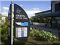
North Swindon District Centre [1]
Better known as the Orbital Shopping Park, all the usual suspects are here. The park has 16 units totalling 212,000 square feet, 990 car parks and claims a footfall of 5 million per annum.
Image: © Michael Dibb
Taken: 3 Apr 2019
0.16 miles
7
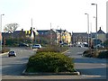
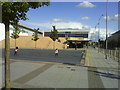
A view towards Haydon Wick
The parish of Haydon Wick once marked the extent of Swindon's built up area. Then the Northern Expansion Area was conceived in the 1980s and execution began in the 1990s. The traffic lights in the centre of the image mark the position of Thamesdown Drive crossing the image right to left, the main 40 mph dual-carriageway through the NEA from which all the sub-areas derive access. The buildings in the background are the new part of Haydon Wick and are in the next square south.
Image: © Brian Robert Marshall
Taken: 16 Feb 2008
0.16 miles
8
Capesthorne Drive, Haydon Wick
Modern housing in Greater Swindon.
Image: © Jonathan Billinger
Taken: 10 Dec 2009
0.17 miles
9
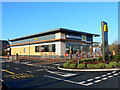
View in the car park, Orbital Retail Park, Swindon
The McDonald's drive-thru is quite new and isn't yet on Google Earth, which was last updated in March 2007 at this location. This being 25 December, the retail park is deserted and the McDonald's closed.
Image: © Brian Robert Marshall
Taken: 25 Dec 2009
0.17 miles
10
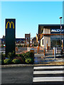
McDonald's Drive-Thru, Orbital Retail Park, Swindon
This example of the popular and much-loved fast food outlets is fairly new having been built since March 2007, the last time one of the Google Earth planes flew over. It is on the north-western corner of the large retail park, conveniently located for shoppers who have maxed out their credit cards at the nearby Asda Walmart, Next or Marks and Spencer's.
Image: © Brian Robert Marshall
Taken: 25 Dec 2009
0.19 miles