IMAGES TAKEN NEAR TO
Cloudberry Road, SWINDON, SN25 1SD
Introduction
This page details the photographs taken nearby to Cloudberry Road, SN25 1SD by members of the Geograph project.
The Geograph project started in 2005 with the aim of publishing, organising and preserving representative images for every square kilometre of Great Britain, Ireland and the Isle of Man.

There are currently over 7.5m images from over14,400 individuals and you can help contribute to the project by visiting https://www.geograph.org.uk
Image Map
Images are licensed for reuse under creativecommons.org/licenses/by-sa/2.0
Notes
- Clicking on the map will re-center to the selected point.
- The higher the marker number, the further away the image location is from the centre of the postcode.
Image Listing (16 Images Found)
Images are licensed for reuse under creativecommons.org/licenses/by-sa/2.0
Image
Details
Distance
1
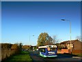
Westfield Way, Swindon
Westfield Way is a suburban road through north Swindon. It acts as a boundary between the area of the town developed in the 1970s and earlier to the left and newer development that started in the late 1980s and which is still ongoing.
Image: © Brian Robert Marshall
Taken: 29 Nov 2007
0.07 miles
2
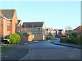
Capesthorne Drive, Haydon Wick
Modern housing in Greater Swindon.
Image: © Jonathan Billinger
Taken: 10 Dec 2009
0.13 miles
3
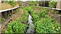
Haydon Wick Brook, Swindon (4)
One of a few photos showing a completed flood alleviation scheme in north Swindon. More below...
Image: © Brian Robert Marshall
Taken: 27 Apr 2014
0.15 miles
4
Haydonleigh Primary School, Haydon Court Drive
Image: © Vieve Forward
Taken: 18 Feb 2012
0.15 miles
5
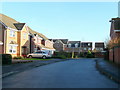
Osterley Road, Haydon Wick
Modern housing in Greater Swindon.
Image: © Jonathan Billinger
Taken: 10 Dec 2009
0.16 miles
6
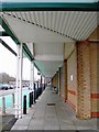
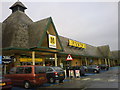
Morrison's supermarket, Thames Avenue, Swindon
This medium sized retail outlet started life in the 1990s as a Safeway store. It was re-branded Morrison's after Safeway was taken over by Morrison a few years ago. The entrance to the store is at the far end of this covered walkway.
Image: © Brian Robert Marshall
Taken: 14 Mar 2007
0.16 miles
7
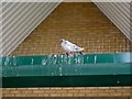
Pigeon, Morrison's, Thames Avenue, Swindon
Despite the installation of anti-perching measures, this feral pigeon proves that where there's a will there's a way.
Image: © Brian Robert Marshall
Taken: 14 Mar 2007
0.17 miles
8
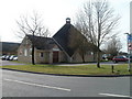
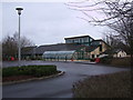
St John the Evangelist church, Haydon Wick, Swindon
Church of England church located on the corner of Thames Avenue and Westfield Way.
The modern church building is designed for both worship and community use. It contains several rooms of various sizes.
Image: © Jaggery
Taken: 12 Mar 2011
0.18 miles
9

Haydon Wick Brook, Swindon (3)
One of a few photos showing a completed flood alleviation scheme in north Swindon. More below...
Image: © Brian Robert Marshall
Taken: 27 Apr 2014
0.19 miles