IMAGES TAKEN NEAR TO
Brookdene, SWINDON, SN25 1RY
Introduction
This page details the photographs taken nearby to Brookdene, SN25 1RY by members of the Geograph project.
The Geograph project started in 2005 with the aim of publishing, organising and preserving representative images for every square kilometre of Great Britain, Ireland and the Isle of Man.

There are currently over 7.5m images from over14,400 individuals and you can help contribute to the project by visiting https://www.geograph.org.uk
Image Map
Images are licensed for reuse under creativecommons.org/licenses/by-sa/2.0
Notes
- Clicking on the map will re-center to the selected point.
- The higher the marker number, the further away the image location is from the centre of the postcode.
Image Listing (27 Images Found)
Images are licensed for reuse under creativecommons.org/licenses/by-sa/2.0
Image
Details
Distance
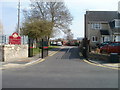
1
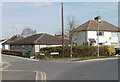
Left for High Street or right for High Street, Haydon Wick, Swindon
At the north end of a road named The Brow, signs direct you left for High Street ( mainly the odd-numbered houses) or right for (the older part of) High Street.
Image: © Jaggery
Taken: 12 Mar 2011
0.04 miles
2
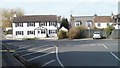
Corner of Blunsdon Road and High Street, Haydon Wick, Swindon
Viewed from High Street across the SW end of Blunsdon Road.
Image: © Jaggery
Taken: 12 Mar 2011
0.09 miles
3
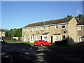
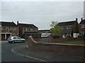
Francomes
1970s houses in Haydon Wick.
Image: © Burgess Von Thunen
Taken: 16 Oct 2011
0.09 miles
4
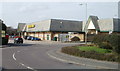
Morrisons Swindon
The SE section of the supermarket, viewed across Thames Avenue.
Image: © Jaggery
Taken: 12 Mar 2011
0.09 miles
5
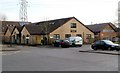
Surgery and pharmacy, Thames Avenue, Swindon
Home Ground Surgery, on the left, and Homeground Pharmacy (name spelt as one word) are located opposite a Morrison's supermarket. http://www.geograph.org.uk/photo/2305043
Image: © Jaggery
Taken: 12 Mar 2011
0.09 miles
6
An entrance to Haydon Wick Primary School
The entrance to the school (and to Barn Own Pre-school) is from a road named The Brow. There is another entrance on the High Street side of the school.
Image: © Jaggery
Taken: 12 Mar 2011
0.10 miles
7
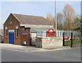
1st Swindon Sea Scouts hall, Haydon Wick
Located on a road named The Brow, next to an entrance http://www.geograph.org.uk/photo/2306696 to Haydon Wick Primary School.
Sea scouting traces its origins back to 1909. Its early development paralleled that of the land-based scouting movement. The majority of sea scout centres are in coastal areas, or near the Thames in London. However, there are groups in most inland counties, such as here in Wiltshire.
Image: © Jaggery
Taken: 12 Mar 2011
0.10 miles
8
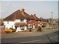
The Brow, Haydon Wick, Swindon
Houses on the west side of The Brow, a gently rising road between The Street and High Street, Haydon Wick.
Image: © Jaggery
Taken: 12 Mar 2011
0.10 miles
9
Wicks Close
1980s houses in Haydon Wick.
Image: © Burgess Von Thunen
Taken: 11 Aug 2012
0.11 miles
10
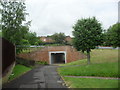
Haydon Wick
Underpass under Haydonleigh Drive.
Image: © Burgess Von Thunen
Taken: 6 Jun 2012
0.11 miles