IMAGES TAKEN NEAR TO
Wood Hall Drive, SWINDON, SN2 2RA
Introduction
This page details the photographs taken nearby to Wood Hall Drive, SN2 2RA by members of the Geograph project.
The Geograph project started in 2005 with the aim of publishing, organising and preserving representative images for every square kilometre of Great Britain, Ireland and the Isle of Man.

There are currently over 7.5m images from over14,400 individuals and you can help contribute to the project by visiting https://www.geograph.org.uk
Image Map
Images are licensed for reuse under creativecommons.org/licenses/by-sa/2.0
Notes
- Clicking on the map will re-center to the selected point.
- The higher the marker number, the further away the image location is from the centre of the postcode.
Image Listing (14 Images Found)
Images are licensed for reuse under creativecommons.org/licenses/by-sa/2.0
Image
Details
Distance
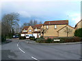
1
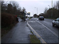
Westfield Way, approaching the Woodhall Park roundabout
Image: © Vieve Forward
Taken: 18 Feb 2012
0.06 miles
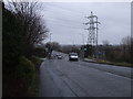
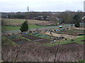
3
View from Akers Roundabout, Moredon
View from Akers Roundabout, showing allotments, houses and pylon.
Image: © Vieve Forward
Taken: 18 Feb 2012
0.09 miles
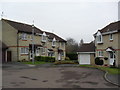
4
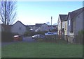
Housing estate, Moredon
Part of the huge northwestern expansion of Swindon.
Image: © Roger Cornfoot
Taken: 10 Jan 2007
0.10 miles
5
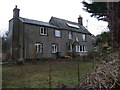
House, Purton Road, Moredon
No. 46 is one of the older houses surviving in Purton Road, Moredon.
Image: © Vieve Forward
Taken: 18 Feb 2012
0.12 miles
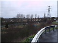
6
Moredon allotments, Akers Way
A 30-plot site. Note the new perimeter fencing.
Image: © Vieve Forward
Taken: 18 Feb 2012
0.14 miles
7
Comfrey Close
1990s houses in Haydon Wick.
Image: © Burgess Von Thunen
Taken: 29 Feb 2012
0.20 miles
8
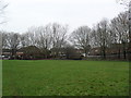
Haydon Wick
Playing fields in Swindon.
Image: © Burgess Von Thunen
Taken: 29 Feb 2012
0.20 miles
9
Periwinkle Close, Pembroke Park, Swindon
Pembroke Park was developed in the 1980s on the site of a municipal power station that was closed and demolished in the 1970s. The development pre-dates, and is south of, the large Northern Development Area known generically as Abbey Meads.
Image: © Brian Robert Marshall
Taken: 24 Jan 2007
0.21 miles
10
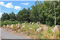
Haydon Henge
Henge Stones off Thamesdown Drive, Swindon.
Image: © Wayland Smith
Taken: 13 Jun 2020
0.21 miles