IMAGES TAKEN NEAR TO
Montrose Close, SWINDON, SN2 2JS
Introduction
This page details the photographs taken nearby to Montrose Close, SN2 2JS by members of the Geograph project.
The Geograph project started in 2005 with the aim of publishing, organising and preserving representative images for every square kilometre of Great Britain, Ireland and the Isle of Man.

There are currently over 7.5m images from over14,400 individuals and you can help contribute to the project by visiting https://www.geograph.org.uk
Image Map
Images are licensed for reuse under creativecommons.org/licenses/by-sa/2.0
Notes
- Clicking on the map will re-center to the selected point.
- The higher the marker number, the further away the image location is from the centre of the postcode.
Image Listing (9 Images Found)
Images are licensed for reuse under creativecommons.org/licenses/by-sa/2.0
Image
Details
Distance
1
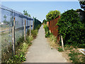
Footpath west of Montrose Close, Moredon, Swindon
This footpath connects Moredon Road to the north with Akers Way. At the left is the fence marking the boundary of a school.
Image: © Brian Robert Marshall
Taken: 2 Jul 2009
0.07 miles
3
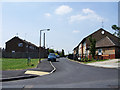
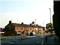
Fernham Road, Moredon, Swindon
Fernham Road is another road in the post-war Council estate of Moredon. Leaving it to the right is the entrance to Chilton Gardens, a sheltered housing scheme for elderly residents.
Image: © Brian Robert Marshall
Taken: 2 Jul 2009
0.13 miles
4
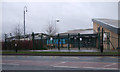
Moredon Primary School, Moredon Road
Moredon Primary and Nursery School and Children's Centre. Note the small figures outside the entrance.
Image: © Vieve Forward
Taken: 18 Feb 2012
0.14 miles
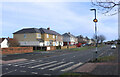
6
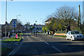
Houses in Moredon Road, Swindon
This terrace of houses in perhaps Edwardian or a little later. Moredon Road can be seen in the foreground and leading away to the right. The road exiting the mini-roundabout to the left is Bourne Road which leads into part of the post-war local authority-built Moredon estate.
Image: © Brian Robert Marshall
Taken: 13 May 2008
0.18 miles
7
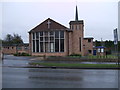
Saint Andrew's Methodist Church, Moredon Road
Formed in around 1962 following the amalgamation of the churches in Rodbourne Cheney, Moredon and Haydon Wick. http://www.standrewsmethodistchurchswindon.btck.co.uk/
Image: © Vieve Forward
Taken: 18 Feb 2012
0.23 miles
8
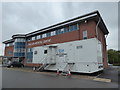
Mobile Breast Screening Service outside Moredon Medical Centre
Image: © Vieve Forward
Taken: 27 Apr 2018
0.24 miles
9
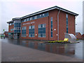
Moredon Medical Centre, Moredon Road
The new Moredon NHS Medical Centre was built when surgeries at Queens Park and 33-35 Moredon Road were no longer adequate to deliver high quality primary care. A site on Moredon Road became available with the relocation of part of Hreod Parkway school, and part of the old school playing field was bought from Swindon Council. The new combined medical practice was built there and opened in September 2009. It has 10 nurse consulting/treatment rooms, 10 medical consulting rooms, a large health education room on the first floor, and a large administration area and a private chiropractic suite on the second floor.
http://www.moredonmedicalcentre.nhs.uk/index.php?id=75
Image: © Vieve Forward
Taken: 18 Feb 2012
0.24 miles