IMAGES TAKEN NEAR TO
Bourne Road, SWINDON, SN2 2JL
Introduction
This page details the photographs taken nearby to Bourne Road, SN2 2JL by members of the Geograph project.
The Geograph project started in 2005 with the aim of publishing, organising and preserving representative images for every square kilometre of Great Britain, Ireland and the Isle of Man.

There are currently over 7.5m images from over14,400 individuals and you can help contribute to the project by visiting https://www.geograph.org.uk
Image Map
Images are licensed for reuse under creativecommons.org/licenses/by-sa/2.0
Notes
- Clicking on the map will re-center to the selected point.
- The higher the marker number, the further away the image location is from the centre of the postcode.
Image Listing (26 Images Found)
Images are licensed for reuse under creativecommons.org/licenses/by-sa/2.0
Image
Details
Distance
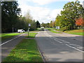
2
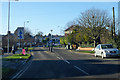
Houses in Moredon Road, Swindon
This terrace of houses in perhaps Edwardian or a little later. Moredon Road can be seen in the foreground and leading away to the right. The road exiting the mini-roundabout to the left is Bourne Road which leads into part of the post-war local authority-built Moredon estate.
Image: © Brian Robert Marshall
Taken: 13 May 2008
0.16 miles
3
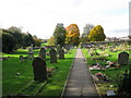
Looking W along church path through graveyard
Image: © Nick Smith
Taken: 28 Oct 2009
0.16 miles
5
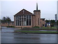
Saint Andrew's Methodist Church, Moredon Road
Formed in around 1962 following the amalgamation of the churches in Rodbourne Cheney, Moredon and Haydon Wick. http://www.standrewsmethodistchurchswindon.btck.co.uk/
Image: © Vieve Forward
Taken: 18 Feb 2012
0.18 miles
6
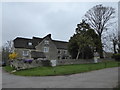
Manor House and Manor Cottage, Cheney Manor Road
Grade II* listed building built of Swindon stone. The core, with the wide gable end facing the camera, dates from the late 16th century. The right wing was added in the 18th century. The dairy to the left was added in the early 19th century and had a hayloft over it. http://www.britishlistedbuildings.co.uk/101023468-manor-house-and-manor-cottage-rodbourne-cheney-ward#.WMqvLmesmUk
Image: © Vieve Forward
Taken: 16 Mar 2017
0.18 miles
7
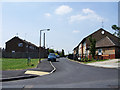
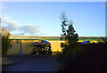
Fernham Road, Moredon, Swindon
Fernham Road is another road in the post-war Council estate of Moredon. Leaving it to the right is the entrance to Chilton Gardens, a sheltered housing scheme for elderly residents.
Image: © Brian Robert Marshall
Taken: 2 Jul 2009
0.20 miles
9
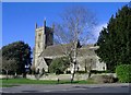
St Mary's church, Rodbourne Cheney
Located a mile northwest of Swindon's town centre.
Image: © Roger Cornfoot
Taken: 10 Jan 2007
0.21 miles