1
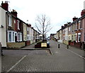
Morris Street, Rodbourne
Like a number of streets in the Rodbourne area of Swindon, part of Morris Street has been pedestrianised. The houses opposite those in this view were demolished to provide a public car park, much of which is reserved during the day for the tenants of The Shaftesbury Centre in Percy Street. This view is looking towards Rodbourne Road. The black & white building on the left is the Morris Street Working Men's Club.
Image
Image: © P L Chadwick
Taken: 12 Dec 2008
0.01 miles
2
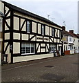
Morris Street Working Men's Club, 20-22 Morris Street, Rodbourne
This part of Swindon developed in the late 19th century, fuelled by the expansion of the nearby railway works. Strangely very few public houses were opened in this area, but to compensate there were a lot of working men's clubs, of which this is a surviving example. Judging by the appearance of the building and its alignment with the adjoining properties, the building the club occupies looks a lot older than the rest of the street. Possibly it was a former farmhouse. If so, it would have been starting a tradition still followed today. The Council's new housing estates in the west and north of the town are each allocated a site for a public house, and some of these have been former farmhouses now turned into pubs.
Image: © P L Chadwick
Taken: 12 Dec 2008
0.01 miles
3
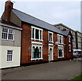
Pedestrianised Morris Street, Swindon
This NE end of the street is pedestrianised, with a parking area on the left.
Morris Street Club http://www.geograph.org.uk/photo/4402437 is on the right.
Image: © Jaggery
Taken: 15 Mar 2015
0.01 miles
4
St Augustines Church Rodbourne Swindon
Image: © Peter Watkins
Taken: 21 Jan 2006
0.02 miles
5
Morris Street
Late 19th Century terraced housing in Morris Street, first shown on the 1900 25 inch map. The exception is the building on the far right of the photo, the former Morris Street Club, which was marked on the 1886 1:500 town plan, the only building shown there on the north side of Morris Street, even though the south side was shown as largely developed. For closer view see
Image
Image: © Ian Capper
Taken: 14 Jul 2022
0.02 miles
6
Morris Street, Rodbourne
This is part of the pedestrianised section of Morris Street, looking towards its junction with Morrison Street. The result of the pedestrianisation of many streets here is that, at times, it is very difficult for residents to park their cars. A problem exacerbated by having to compete with shoppers at the nearby Swindon Designer Outlet who want to avoid paying car parking fees. For the view in the other direction:
Image
Image: © P L Chadwick
Taken: 12 Dec 2008
0.02 miles
7
Morris Street in Morris Street, Swindon
The name on the wall of the distinctive building at 20-22 Morris Street, and on the sign on the right, is identical with the street name. Online references show Morris Street Club, previously Morris Street Working Men's Club.
Image: © Jaggery
Taken: 15 Mar 2015
0.03 miles
8
Former Morris Street Club
Working men's club in Morris Street which closed in 2015, with conversion to housing proposed for the building. The building was marked on the 1886 1:500 town plan and was the only building shown on the north side of Morris Street, even though the south side was shown as largely developed.
Image: © Ian Capper
Taken: 14 Jul 2022
0.03 miles
9
Morris Street, Swindon
Looking SW from the middle of the 160 metre long pedestrianised zone at the NE end of Morris Street.
Distant cars are parked near the edge of the zone. The road on the left leads to a parking area.
Image: © Jaggery
Taken: 15 Mar 2015
0.05 miles
10
Even Swindon Working Men's Club & Institute, Swindon
Located at 44 Percy Street in the pedestrianised middle part of the street.
A name sign states that the club was established in 1883.
Image: © Jaggery
Taken: 15 Mar 2015
0.05 miles


