IMAGES TAKEN NEAR TO
Summers Street, SWINDON, SN2 2HA
Introduction
This page details the photographs taken nearby to Summers Street, SN2 2HA by members of the Geograph project.
The Geograph project started in 2005 with the aim of publishing, organising and preserving representative images for every square kilometre of Great Britain, Ireland and the Isle of Man.

There are currently over 7.5m images from over14,400 individuals and you can help contribute to the project by visiting https://www.geograph.org.uk
Image Map
Images are licensed for reuse under creativecommons.org/licenses/by-sa/2.0
Notes
- Clicking on the map will re-center to the selected point.
- The higher the marker number, the further away the image location is from the centre of the postcode.
Image Listing (216 Images Found)
Images are licensed for reuse under creativecommons.org/licenses/by-sa/2.0
Image
Details
Distance
1
St Augustines Church Rodbourne Swindon
Image: © Peter Watkins
Taken: 21 Jan 2006
0.02 miles
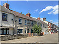
2
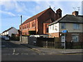
Morris Street, Rodbourne
Like a number of streets in the Rodbourne area of Swindon, part of Morris Street has been pedestrianised. The houses opposite those in this view were demolished to provide a public car park, much of which is reserved during the day for the tenants of The Shaftesbury Centre in Percy Street. This view is looking towards Rodbourne Road. The black & white building on the left is the Morris Street Working Men's Club. Image
Image: © P L Chadwick
Taken: 12 Dec 2008
0.03 miles
3
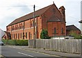
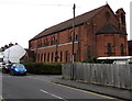
Parish Church of St. Augustine of Canterbury, Summers Street
This large Anglican church, built of red brick, to an unusual but attractive design, dates from 1908. It serves the Rodbourne area of the town which, decades ago, was mainly home to workers in the former nearby railway works and their families. The church was never fuly completed. If the original plans had been followed, its area would be twice as large as it is now.
The church is dedicated to St. Augustine, who was the first Archbishop of Canterbury. He was sent by the church in Rome to England in 596 AD, and was later made Archbishop. He died in the early 7th century.
Image
Image
Image: © P L Chadwick
Taken: 5 Oct 2010
0.03 miles
4
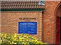
Parish Church of St. Augustine of Canterbury - sign
Above the blue and white sign, are the words Even Swindon. This used to be the name given to this part of Swindon years ago, but apart, possibly, from the very elderly, nobody calls it that now, not even estate agents! Today it is known as Rodbourne.
Image
Image
Image: © P L Chadwick
Taken: 5 Oct 2010
0.03 miles
5
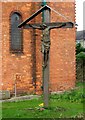
Parish Church of St. Augustine of Canterbury - carving of Christ on the Cross
Image: © P L Chadwick
Taken: 5 Oct 2010
0.03 miles
6
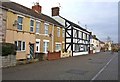
Morris Street
Late 19th Century terraced housing in Morris Street, first shown on the 1900 25 inch map. The exception is the building on the far right of the photo, the former Morris Street Club, which was marked on the 1886 1:500 town plan, the only building shown there on the north side of Morris Street, even though the south side was shown as largely developed. For closer view see Image
Image: © Ian Capper
Taken: 14 Jul 2022
0.03 miles
7
St Augustine, Even Swindon, Swindon
Viewed across Summers Street from the Rodbourne Road end.
The Parish Church of St Augustine of Canterbury is part of the Church of England Diocese of Bristol.
Image: © Jaggery
Taken: 15 Mar 2015
0.04 miles
8
Former Morris Street Club
Working men's club in Morris Street which closed in 2015, with conversion to housing proposed for the building. The building was marked on the 1886 1:500 town plan and was the only building shown on the north side of Morris Street, even though the south side was shown as largely developed.
Image: © Ian Capper
Taken: 14 Jul 2022
0.04 miles
9
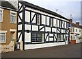
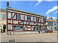
Morris Street Working Men's Club, 20-22 Morris Street, Rodbourne
This part of Swindon developed in the late 19th century, fuelled by the expansion of the nearby railway works. Strangely very few public houses were opened in this area, but to compensate there were a lot of working men's clubs, of which this is a surviving example. Judging by the appearance of the building and its alignment with the adjoining properties, the building the club occupies looks a lot older than the rest of the street. Possibly it was a former farmhouse. If so, it would have been starting a tradition still followed today. The Council's new housing estates in the west and north of the town are each allocated a site for a public house, and some of these have been former farmhouses now turned into pubs.
Image: © P L Chadwick
Taken: 12 Dec 2008
0.04 miles
10
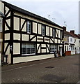
Morris Street in Morris Street, Swindon
The name on the wall of the distinctive building at 20-22 Morris Street, and on the sign on the right, is identical with the street name. Online references show Morris Street Club, previously Morris Street Working Men's Club.
Image: © Jaggery
Taken: 15 Mar 2015
0.04 miles