IMAGES TAKEN NEAR TO
Ferndale Road, SWINDON, SN2 1BX
Introduction
This page details the photographs taken nearby to Ferndale Road, SN2 1BX by members of the Geograph project.
The Geograph project started in 2005 with the aim of publishing, organising and preserving representative images for every square kilometre of Great Britain, Ireland and the Isle of Man.

There are currently over 7.5m images from over14,400 individuals and you can help contribute to the project by visiting https://www.geograph.org.uk
Image Map
Images are licensed for reuse under creativecommons.org/licenses/by-sa/2.0
Notes
- Clicking on the map will re-center to the selected point.
- The higher the marker number, the further away the image location is from the centre of the postcode.
Image Listing (138 Images Found)
Images are licensed for reuse under creativecommons.org/licenses/by-sa/2.0
Image
Details
Distance
1
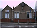
Ferndale Working Men's Club, Ferndale Road, Swindon
Ferndale Club and Institute is a typical workingmen's club offering beer and skittles. It is also a venue for pigeon racing, and the monthly meetings of the Gorse Hill Pigeon Racing Club are held on the premises.
Image: © Vieve Forward
Taken: 25 Jan 2012
0.00 miles
2
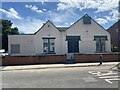
Ferndale Club and Institute, Swindon
Ferndale is a village in the Rhondda from which several Welsh workers came to work in the railway industry.
Image: © Alan Hughes
Taken: 14 Jul 2022
0.01 miles
3
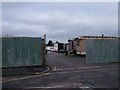
Edwards Amusement Depot entrance, Ferndale Road, Swindon
Entrance to Edwards Amusement Depot. There are some small dwellings inside, but mainly the space is used to store mobile catering vans and the like.
Image: © Vieve Forward
Taken: 25 Jan 2012
0.03 miles
4
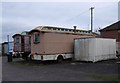
Old caravans in Edwards Amusement Depot, Ferndale Road, Swindon
Edwards Amusement Depot contains some newer dwellings, as well as these beautiful old caravans, and is mainly used as a storage place for mobile catering vans.
Image: © Vieve Forward
Taken: 25 Jan 2012
0.03 miles
5
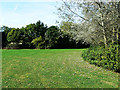
St Mark's recreation ground, Florence Street, Swindon
This is the eastern end of a relatively small but much-valued recreational area in the Gorsehill area of Swindon, north of the railway line which bisects the town.
Image: © Brian Robert Marshall
Taken: 11 Sep 2009
0.03 miles
6
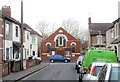
Florence Street Mission Hall, Swindon
Viewed along Whiteman Street. The year 1903 is inscribed in stone at the top of the building.
Image: © Jaggery
Taken: 12 Mar 2011
0.04 miles
7
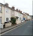
Florence Street, Swindon
Houses on the east side of the street, viewed from near the Mission Hall. http://www.geograph.org.uk/photo/2360820
Image: © Jaggery
Taken: 12 Mar 2011
0.04 miles
8
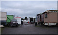
Edwards Amusement Depot, Ferndale Road, Swindon
Edwards Amusement Depot contains some small dwellings (the white buildings in the background), but mainly the space is used to store mobile catering vans and the like. Particularly interesting are the old caravans near the entrance.
Image: © Vieve Forward
Taken: 25 Jan 2012
0.04 miles
9
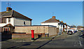
Corner of Norman Road
I passed several Royal Mail post boxes on my walk today. Most of them seemed to be leaning a bit.
Image: © Des Blenkinsopp
Taken: 19 Jan 2020
0.05 miles
10
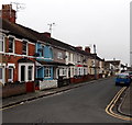
Florence Street towards Ferndale Road, Swindon
Houses on the west side of Florence Street viewed from the corner of Whiteman Street
looking north towards Ferndale Road. Florence Street Mission Hall http://www.geograph.org.uk/photo/4265807 is nearby.
Image: © Jaggery
Taken: 1 Dec 2014
0.07 miles