IMAGES TAKEN NEAR TO
Prunus Walk, SN1 7ET
Introduction
This page details the photographs taken nearby to Prunus Walk, SN1 7ET by members of the Geograph project.
The Geograph project started in 2005 with the aim of publishing, organising and preserving representative images for every square kilometre of Great Britain, Ireland and the Isle of Man.

There are currently over 7.5m images from over14,400 individuals and you can help contribute to the project by visiting https://www.geograph.org.uk
Image Map
Images are licensed for reuse under creativecommons.org/licenses/by-sa/2.0
Notes
- Clicking on the map will re-center to the selected point.
- The higher the marker number, the further away the image location is from the centre of the postcode.
Image Listing (27 Images Found)
Images are licensed for reuse under creativecommons.org/licenses/by-sa/2.0
Image
Details
Distance
1
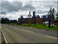
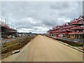
New housing, Scott Way, Wichelstowe, Swindon
A somewhat futuristic take on basically traditional house-building techniques, it would appear.
Image: © Brian Robert Marshall
Taken: 12 Jul 2023
0.05 miles
2
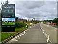
New housing development, Scott Way, Wichelstowe, Swindon
There is considerable new housing development in this area of Swindon.
Image: © Brian Robert Marshall
Taken: 12 Jul 2023
0.06 miles
3
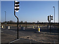
Road under construction linking Wichelstowe and Wootton Bassett
This is the new road linking Wichelstowe to Wootton Bassett in the process of construction. At the moment, it stops short of the minor road to South Leaze. This photograph shows the stub southwards to the as yet unbuilt West Wichel.
Image: © Vieve Forward
Taken: 2 Feb 2012
0.07 miles
4
Road under construction linking Wichelstowe and Wootton Bassett
This is the new road linking Wichelstowe to Wootton Bassett in the process of construction. At the moment, it stops short of the minor road to South Leaze, with a stub southwards to the as yet unbuilt West Wichel.
Image: © Vieve Forward
Taken: 2 Feb 2012
0.08 miles
5
Road linking Wichelstowe to Wootton Bassett under construction
This is the new road linking Wichelstowe to Wootton Bassett in the process of construction. At the moment, it stops short of the minor road to South Leaze, with a stub southwards to the as yet unbuilt West Wichel.
Image: © Vieve Forward
Taken: 2 Feb 2012
0.08 miles
6
New housing development, Elcombe Road, Wichelstowe, Swindon
This part of Elcombe Road passes along the line of a public footpath. When completed the road will enable traffic to pass under the M4 to Bassett Down.
Image: © Brian Robert Marshall
Taken: 12 Jul 2023
0.16 miles
7

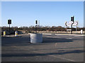
Swindon: Redposts Drive Link Road bridge
The plans for the creation of Swindon's Southern Development Area include the extension of the existing Redposts Drive road southwards into the area. However the embankment of the former Midland and South Western Junction Railway (M&SWJR) line, which is now a footpath and part of National Cycle Route 45, has had to be breached and the new bridge for pedestrians and cyclists is seen here under construction.
Image: © Nigel Cox
Taken: 26 Oct 2007
0.20 miles
8
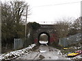
Bridge under Great Western Main Line, Swindon
Image: © Gareth James
Taken: 27 Dec 2010
0.20 miles
9
Site of Rushey Platt Junction, Swindon
The former Midland & South Western Junction Railway descended from Swindon Town station (Old Town station), behind. The main MSWJ route went straight ahead (on the left), soon crossing the Great Western main line, then continuing towards Cirencester and Cheltenham. The route on the right curved around, descending further, to join the Great Western line into Swindon Junction station (which is the current Swindon station).
This path on the left is now part of National Cycle Network Route 45.
Image: © Gareth James
Taken: 27 Dec 2010
0.21 miles
10
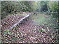
Swindon: Former Rushey Platt railway station
Rushey Platt station was on the former Midland and South Western Junction Railway (M&SWJR) between Swindon Town and Cirencester stations, and was opened in 1883. A short link line to the GWR main line also ran from the station and there was a low level platform on the link line and a high level platform on the main line. I think that the platform remains visible in this photograph are from the main line. There is a truly excellent website, with copious photographs, detailing the history of the M&SWJR here http://www.swindonsotherrailway.co.uk/leftnav.html and a specific photo showing the arrangements of Rushey Platt station, probably in the 1930s from the same website here http://www.swindonsotherrailway.co.uk/mike90.html
Image: © Nigel Cox
Taken: 26 Oct 2007
0.21 miles