IMAGES TAKEN NEAR TO
Semington Strand, SN1 7DL
Introduction
This page details the photographs taken nearby to Semington Strand, SN1 7DL by members of the Geograph project.
The Geograph project started in 2005 with the aim of publishing, organising and preserving representative images for every square kilometre of Great Britain, Ireland and the Isle of Man.

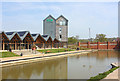
There are currently over 7.5m images from over14,400 individuals and you can help contribute to the project by visiting https://www.geograph.org.uk
Image Map
Images are licensed for reuse under creativecommons.org/licenses/by-sa/2.0
Notes
- Clicking on the map will re-center to the selected point.
- The higher the marker number, the further away the image location is from the centre of the postcode.
Image Listing (80 Images Found)
Images are licensed for reuse under creativecommons.org/licenses/by-sa/2.0
Image
Details
Distance
1
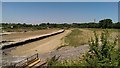
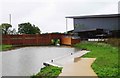
Wilts and Berks canal, Peglars Way, Swindon
This is a view facing north-east towards the big houses in Okus Road and St Helens View. In the centre of the image is Beavan's Bridge. The line of sandbags at the left marks the route of a public footpath. Works being carried out behind the viewpoint have necessitated the temporary draining of the canal.
Image: © Brian Robert Marshall
Taken: 5 Jul 2018
0.04 miles
2
Opening Soon
New housing by the Canal at Wichelstowe.
Image: © Wayland Smith
Taken: 12 Aug 2020
0.04 miles
3
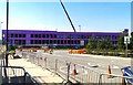
Construction- and road-works, Peglars Way, Swindon
Several things are happening at once in this location. Changes to the road layout to the left are taking place. Work on the Wilts and Berks canal is ongoing as is work on the large building in the background. The purple coloration is cladding.
Image: © Brian Robert Marshall
Taken: 5 Jul 2018
0.05 miles
4
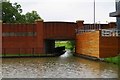
New bridge over Wilts & Berks Canal, Foxham Way, Wichelstowe, Swindon
This recently constructed bridge carries Foxham Way over a restored section of the Wilts & Berks Canal. Also restored is the canal's towpath, which can be seen on the left, behind the railings.
Image
Image: © P L Chadwick
Taken: 23 Aug 2015
0.06 miles
5
Wichelstowe
Development continues apace with the canal in place and the new pub open. A pedestrian bridge crosses the canal here to Waitrose.
Image: © Wayland Smith
Taken: 12 Apr 2020
0.06 miles
6
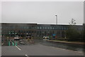
New offices on Peglars Way, Wichelstowe
They have just been finished, here they are a year earlier https://www.geograph.org.uk/photo/5830926
Image: © David Howard
Taken: 26 Oct 2019
0.07 miles
7
Bridge over Wilts & Berks Canal, Swindon
Image: © Gareth James
Taken: 27 Dec 2010
0.07 miles
8
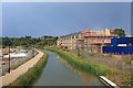
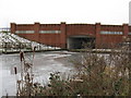
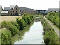
Wilts & Berks Canal and houses on Chaddington Strand (L) and Semington Strand (R)
Image: © Rob Purvis
Taken: 11 Jun 2023
0.07 miles
9
Wilts & Berks Canal by Waitrose Supermarket, Mill Lane, Wichelstowe, Swindon
This section of the long closed Wilts & Berks Canal has been restored and runs alongside the new Waitrose store which opened in April 2014. The Wilts & Berks Canal Trust operates a trip boat which stops here. In the distance is a new bridge which was required to carry a new road across the canal.
Image
Image: © P L Chadwick
Taken: 23 Aug 2015
0.07 miles
10
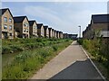
Wilts & Berks Canal at Wichelstowe
Wichelstowe is a major new development on the south side of Swindon. This section of the canal has been restored to a condition where it is navigable.
Image: © Alan Murray-Rust
Taken: 13 Jul 2022
0.07 miles